Canvas Print > Fine Art Storehouse > Map
Canvas Print : Map of Africa


![]()
Canvas Prints from Fine Art Storehouse
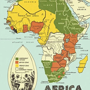
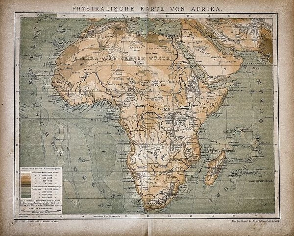
Map of Africa
Antique illustration of a map of Africa
Unleash your creativity and transform your space into a visual masterpiece!
Nastasic
Media ID 13590329
© This content is subject to copyright
African Culture Country Geographic Area Geographical Border International Border Pencil Drawing Politics Politics And Government Relief Map Serbia Sketch Topography Drawing Art Product Obsolete Painted Image Retro Styled Victorian Style
20"x16" (50x40cm) Canvas Print
Discover the rich history and intrigue of Africa with our stunning Canvas Print of "Map of Africa" by Nastasic from the Fine Art Storehouse collection. This captivating antique illustration transports you back in time, showcasing the intricate details of the African continent as it was once known. The high-quality canvas print brings vibrant colors and sharp details to life, making it a stunning addition to any home or office. Decorate your space with a touch of history and adventure - order your "Map of Africa" Canvas Print today!
Ready to hang Premium Gloss Canvas Print. Our archival quality canvas prints are made from Polyester and Cotton mix and stretched over a 1.25" (32mm) kiln dried knot free wood stretcher bar. Packaged in a plastic bag and secured to a cardboard insert for transit.
Canvas Prints add colour, depth and texture to any space. Professionally Stretched Canvas over a hidden Wooden Box Frame and Ready to Hang
Estimated Product Size is 50.8cm x 40.6cm (20" x 16")
These are individually made so all sizes are approximate
Artwork printed orientated as per the preview above, with landscape (horizontal) orientation to match the source image.
FEATURES IN THESE COLLECTIONS
> Fine Art Storehouse
> The Magical World of Illustration
> Nastasic Images & Illustrations
> Fine Art Storehouse
> Map
> Historical Maps
EDITORS COMMENTS
This print showcases an exquisite antique illustration of a Map of Africa, taking us on a journey back to the 19th century. The horizontal composition is rich in retro styling and vibrant colors, evoking a sense of nostalgia for this bygone era. Created with meticulous attention to detail, this engraving beautifully captures the continent's geographic area, including international borders and topographical features. It reflects the artistry and craftsmanship prevalent during the Victorian period, showcasing intricate pencil drawings combined with painted images. As we delve into history through this artwork, we are reminded of the political significance that maps hold. Cartography becomes a powerful tool in understanding cultures and geographical borders within Africa. This piece offers insight into obsolete political divisions while celebrating African culture through its illustration technique. The relief map depicted here adds depth and texture to the overall image, enhancing our visual experience. Every line engraved on this old yet timeless sketch tells stories of exploration and discovery from centuries past. With its undeniable charm and historical value, Nastasic's Map of Africa print serves as both an educational resource and a stunning work of art. Its presence invites us to appreciate not only the beauty found within physical geography but also sparks curiosity about politics and government throughout different periods in time.
MADE IN THE UK
Safe Shipping with 30 Day Money Back Guarantee
FREE PERSONALISATION*
We are proud to offer a range of customisation features including Personalised Captions, Color Filters and Picture Zoom Tools
SECURE PAYMENTS
We happily accept a wide range of payment options so you can pay for the things you need in the way that is most convenient for you
* Options may vary by product and licensing agreement. Zoomed Pictures can be adjusted in the Basket.