Canvas Print > Arts > Artists > H > Wenceslaus Hollar
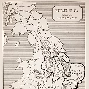
Canvas Print : Map of England and Wales, 1644 (engraving) (b / w photo)
 (b / w photo)")


 (b / w photo)")


![]()
Canvas Prints from Fine Art Finder
Map of England and Wales, 1644 (engraving) (b / w photo)
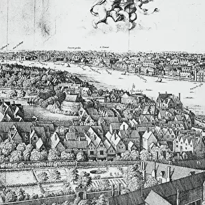
XJF273140 Map of England and Wales, 1644 (engraving) (b/w photo) by Hollar, Wenceslaus (1607-77); Private Collection; Czech, out of copyright
Media ID 12789905
© www.bridgemanart.com
Cities Irish Sea Mapping North Sea British Sea Shires
20"x16" (50x40cm) Canvas Print
Add a touch of history to your home decor with Media Storehouse's Canvas Prints featuring the intricately detailed Map of England and Wales from 1644. This beautiful engraving by master engraver Wenceslaus Hollar showcases the political divisions of the time in stunning black and white detail. A fascinating piece for history enthusiasts or those who appreciate the art of cartography, this canvas print is sure to make a bold and unique statement in any room. With high-quality materials and vibrant colors, our canvas prints are designed to last and bring the intricacies of this historic map to life.
Ready to hang Premium Gloss Canvas Print. Our archival quality canvas prints are made from Polyester and Cotton mix and stretched over a 1.25" (32mm) kiln dried knot free wood stretcher bar. Packaged in a plastic bag and secured to a cardboard insert for transit.
Canvas Prints add colour, depth and texture to any space. Professionally Stretched Canvas over a hidden Wooden Box Frame and Ready to Hang
Estimated Product Size is 50.8cm x 40.6cm (20" x 16")
These are individually made so all sizes are approximate
Artwork printed orientated as per the preview above, with landscape (horizontal) orientation to match the source image.
FEATURES IN THESE COLLECTIONS
> Arts
> Artists
> H
> Wenceslaus Hollar
> Europe
> Czech Republic
> Maps
> Europe
> Republic of Ireland
> Maps
> Europe
> United Kingdom
> England
> Maps
> Europe
> United Kingdom
> England
> Posters
> Europe
> United Kingdom
> England
> Related Images
> Europe
> United Kingdom
> Wales
> Maps
> Europe
> United Kingdom
> Wales
> Posters
> Europe
> United Kingdom
> Wales
> Related Images
> Fine Art Finder
> Artists
> Wenceslaus Hollar
> Fine Art Finder
> Maps (celestial & Terrestrial)
EDITORS COMMENTS
This print showcases a remarkable piece of history - the "Map of England and Wales, 1644". Created by the talented engraver Wenceslaus Hollar, this map is a true testament to his skill and attention to detail. The intricate cartography on display here allows us to explore the shires, cities, and market towns that made up England and Wales during this period. Each region is meticulously labeled, giving us insight into the geographical landscape of the time. One cannot help but be drawn to the coat of arms scattered throughout the map, representing various kings who once ruled these lands. These symbols serve as a reminder of England's rich royal heritage. As we gaze upon this print, our eyes are also captivated by the vast British Sea stretching out towards Ireland in one direction and reaching towards continental Europe in another. The presence of ships sailing across these waters adds an element of movement and adventure to an otherwise static image. This photograph transports us back in time, allowing us to appreciate not only Hollar's artistic talent but also providing a glimpse into what life was like over three centuries ago. It serves as a valuable historical artifact that reminds us of how much has changed while simultaneously celebrating our shared past.
MADE IN THE UK
Safe Shipping with 30 Day Money Back Guarantee
FREE PERSONALISATION*
We are proud to offer a range of customisation features including Personalised Captions, Color Filters and Picture Zoom Tools
SECURE PAYMENTS
We happily accept a wide range of payment options so you can pay for the things you need in the way that is most convenient for you
* Options may vary by product and licensing agreement. Zoomed Pictures can be adjusted in the Basket.