Canvas Print > Europe > France > Maps
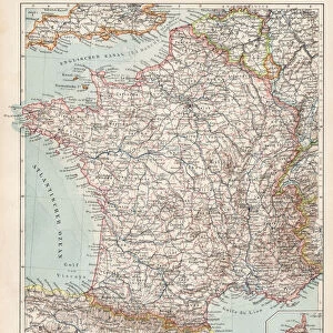
Canvas Print : Map of the frankish kingdom on Chlothar I's death (561) Engraving from " Atlas Universel" by Houze 1851 Private collection
 Engraving from ' Atlas Universel' by Houze 1851 Private collection")
 Engraving from ' Atlas Universel' by Houze 1851 Private collection")


![]()
Canvas Prints From Fine Art Finder
Map of the frankish kingdom on Chlothar I's death (561) Engraving from " Atlas Universel" by Houze 1851 Private collection
ELD4921543 Map of the frankish kingdom on Chlothar I's death (561) Engraving from " Atlas Universel" by Houze 1851 Private collection; (add.info.: Map of the frankish kingdom on Chlothar I's death (561) Engraving from " Atlas Universel" by Houze 1851 Private collection); Photo © The Holbarn Archive
Media ID 38480134
© © The Holbarn Archive / Bridgeman Images
6 6th Vi Vith Century 6th 6th 6th Vi Vith Vith Century 6th Century C6th Franks Merovagians Merovingian Dynasty Monarchic Royalism Sixth Century Ad Vi Century Vith Century Geographical Map Isadora
20"x16" (50x40cm) Canvas Print
Explore our collection of Canvas Prints featuring historical maps, like this detailed engraving of the Frankish Kingdom on Chlothar I's death in 561. Perfect for adding a touch of sophistication to any space.
Ready to hang Premium Gloss Canvas Print. Our archival quality canvas prints are made from Polyester and Cotton mix and stretched over a 1.25" (32mm) kiln dried knot free wood stretcher bar. Packaged in a plastic bag and secured to a cardboard insert for transit.
Canvas Prints add colour, depth and texture to any space. Professionally Stretched Canvas over a hidden Wooden Box Frame and Ready to Hang
Estimated Product Size is 50.8cm x 40.6cm (20" x 16")
These are individually made so all sizes are approximate
Artwork printed orientated as per the preview above, with landscape (horizontal) orientation to match the source image.
FEATURES IN THESE COLLECTIONS
> Maps and Charts
> Early Maps
> Maps and Charts
> Related Images
> Fine Art Finder
> Artists
> Spanish School (after)
EDITORS COMMENTS
This stunning print captures a detailed engraving of the Map of the Frankish Kingdom on Chlothar I's death in 561. Created by Houze in 1851 for the "Atlas Universel," this historical piece is now part of a private collection, showcasing the intricate borders and territories of the Frankish Empire during this significant period.
Chlothar I, also known as Clotaire I, was a key figure in Merovingian history and ruled over the Franks from 497 to 561. This map provides a visual representation of his kingdom at the time of his passing, offering insight into the political landscape and geographical boundaries of Europe during the sixth century AD.
The engraving is rich in detail, highlighting major cities, rivers, and regions that were under Chlothar I's reign. It serves as a valuable historical artifact, shedding light on the monarchy and royalism that characterized this era.
As we gaze upon this image from the 19th century, we are transported back in time to witness the power and influence of one of France's most notable rulers. The Map of the Frankish Kingdom on Chlothar I's death is not just a geographical depiction but a window into an important chapter in European history.
MADE IN THE UK
Safe Shipping with 30 Day Money Back Guarantee
FREE PERSONALISATION*
We are proud to offer a range of customisation features including Personalised Captions, Color Filters and Picture Zoom Tools
SECURE PAYMENTS
We happily accept a wide range of payment options so you can pay for the things you need in the way that is most convenient for you
* Options may vary by product and licensing agreement. Zoomed Pictures can be adjusted in the Basket.