Canvas Print > Fine Art Finder > Artists > Charles Marie Rigobert Bonne
Canvas Print : Map of the World in two Hemispheres, from Atlas de Toutes les Parties Connues


Please select a smaller print size for this image
![]()
Canvas Prints from Fine Art Finder
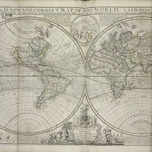
Map of the World in two Hemispheres, from Atlas de Toutes les Parties Connues
KW205841 Map of the World in two Hemispheres, from Atlas de Toutes les Parties Connues du Globe Terrestre by Guillaume Raynal (1713-96) published Geneva, 1780 (coloured engraving) by Bonne, Charles Marie Rigobert (1727-95); Private Collection; Ken Welsh; French, out of copyright
Media ID 12755409
© www.bridgemanimages.com
Continent Hemisphere Latitude Longitude
21"x14" (53x35cm) Canvas Print
Discover the wonders of our interconnected world with the Media Storehouse Canvas Prints featuring the stunning Map of the World in Two Hemispheres. Originally published in 1780 from the atlas "Atlas de Toutes les Parties Connues du Globe Terrestre" by Guillaume Raynal, this intricately detailed map showcases the world as it was known during that time. The vibrant colors of the engraving are brought to life on high-quality canvas, making this a captivating addition to any home or office decor. Travel back in time and explore the rich history of cartography with this beautiful work of art.
Ready to hang Premium Gloss Canvas Print. Our archival quality canvas prints are made from Polyester and Cotton mix and stretched over a 1.25" (32mm) kiln dried knot free wood stretcher bar. Packaged in a plastic bag and secured to a cardboard insert for transit.
Canvas Prints add colour, depth and texture to any space. Professionally Stretched Canvas over a hidden Wooden Box Frame and Ready to Hang
Estimated Product Size is 53.3cm x 35.6cm (21" x 14")
These are individually made so all sizes are approximate
Artwork printed orientated as per the preview above, with landscape (horizontal) orientation to match the source image.
EDITORS COMMENTS
This print showcases the "Map of the World in two Hemispheres" from the renowned Atlas de Toutes les Parties Connues du Globe Terrestre by Guillaume Raynal. Created in 1780, this colored engraving offers a glimpse into the geographical knowledge and cartographic techniques of that era. The map is divided into two hemispheres, providing a comprehensive view of our planet's continents, oceans, longitudes, latitudes, and hemispheric divisions. The intricate details meticulously captured by Charles Marie Rigobert Bonne transport us back to an age when exploration was at its peak. Displayed against a backdrop of warm hues and delicate shading, each landmass comes alive with vibrant colors. From the vastness of America to the sprawling continents across both hemispheres, this map invites viewers on an imaginary journey around the world. As we gaze upon this historical masterpiece held within a private collection and made available through Ken Welsh's collaboration with Fine Art Finder and Bridgeman Images, it serves as a reminder of humanity's insatiable curiosity about our planet. It sparks wonderment about how much has changed since its creation over two centuries ago while also highlighting timeless features that have remained constant throughout history. Whether you are an avid explorer or simply appreciate artistry in cartography, this print transports you to another time and place – inviting contemplation on our ever-evolving understanding of Earth's geography.
MADE IN THE UK
Safe Shipping with 30 Day Money Back Guarantee
FREE PERSONALISATION*
We are proud to offer a range of customisation features including Personalised Captions, Color Filters and Picture Zoom Tools
SECURE PAYMENTS
We happily accept a wide range of payment options so you can pay for the things you need in the way that is most convenient for you
* Options may vary by product and licensing agreement. Zoomed Pictures can be adjusted in the Basket.