Canvas Print > Africa > South Africa > Maps
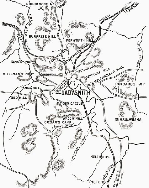
Canvas Print : Map Of Ladysmith And Surrounding Heights Circa. 1900. From The Book South Africa And The Transvaal War By Louis Creswicke, Published 1900


![]()
Canvas Prints from Design Pics
Map Of Ladysmith And Surrounding Heights Circa. 1900. From The Book South Africa And The Transvaal War By Louis Creswicke, Published 1900
Design Pics offers Distinctively Different Imagery representing over 1,500 contributors
Media ID 18191651
© Ken Welsh / Design Pics
Africa African Boer Heights Siege South Surrounding Ladysmith
20"x16" (50x40cm) Canvas Print
Step back in time with our vintage Canvas Print of the Map of Ladysmith and Surrounding Heights, circa 1900. Originally found in the book "South Africa And The Transvaal War" by Louis Creswicke, published in 1900, this historical map showcases the layout of Ladysmith and its surrounding heights during a pivotal period in South African history. Ken Welsh's expert photography brings out the intricate details of this antique map, making it a stunning addition to any home or office space. Our high-quality Canvas Prints are designed to last, with vibrant colors and a textured finish that brings the image to life. Relive history with this unique and captivating piece of art.
Ready to hang Premium Gloss Canvas Print. Our archival quality canvas prints are made from Polyester and Cotton mix and stretched over a 1.25" (32mm) kiln dried knot free wood stretcher bar. Packaged in a plastic bag and secured to a cardboard insert for transit.
Canvas Prints add colour, depth and texture to any space. Professionally Stretched Canvas over a hidden Wooden Box Frame and Ready to Hang
Estimated Product Size is 40.6cm x 50.8cm (16" x 20")
These are individually made so all sizes are approximate
Artwork printed orientated as per the preview above, with portrait (vertical) orientation to match the source image.
FEATURES IN THESE COLLECTIONS
> Africa
> South Africa
> Maps
> Africa
> South Africa
> Related Images
> Maps and Charts
> Related Images
EDITORS COMMENTS
This print takes us back in time to the year 1900, showcasing a detailed map of Ladysmith and its surrounding heights. From the book "South Africa and the Transvaal War" by Louis Creswicke, this historical artifact offers a glimpse into an era marked by conflict and struggle. The map itself is a testament to the significance of Ladysmith during the Second Boer War, as it highlights key locations that played a crucial role in this intense battle. With intricate details and precise markings, it provides valuable insights into the geography of the area at that time. Ken Welsh's expertly captured print allows us to appreciate not only the historical value but also the artistic beauty of this piece. The crisp lines and rich colors make every inch of this map come alive, transporting us back to an important chapter in South African history. As we gaze upon this remarkable image, we are reminded of how maps have always been powerful tools for understanding our world. They tell stories beyond words - tales of conquests, sieges, and territorial disputes. This particular map serves as a visual reminder of Ladysmith's resilience during challenging times. Whether you are a history enthusiast or simply intrigued by beautiful cartography, Ken Welsh's print brings together artistry and historical significance in one captivating piece. It invites us to explore not only Ladysmith but also our own curiosity about past events that have shaped our present reality.
MADE IN THE UK
Safe Shipping with 30 Day Money Back Guarantee
FREE PERSONALISATION*
We are proud to offer a range of customisation features including Personalised Captions, Color Filters and Picture Zoom Tools
SECURE PAYMENTS
We happily accept a wide range of payment options so you can pay for the things you need in the way that is most convenient for you
* Options may vary by product and licensing agreement. Zoomed Pictures can be adjusted in the Basket.