Antique Framed Print > Europe > United Kingdom > England > Sussex > Chithurst
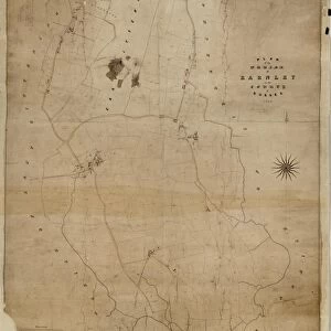
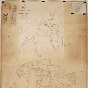
Antique Framed Print : Chithurst Tithe Map, c. 1840


![]()
Framed Photos from West Sussex County Council
Chithurst Tithe Map, c. 1840
No date, but Tithe Award dated 1840. By Frederick & Henry E. Drayson. 26.6 in. to 1 m. Original map size 83in. × 36in.
Tithe Award Map Collection
West Sussex Record Office Ref No: TD/W31
West Sussex County Council Record Office contains a fascinating history of the county of West Sussex, England
Media ID 7915674
© West Sussex County Council - All Rights Reserved
21"x16" (54x41cm) Antique Frame
Bevelled wood effect frame, card mounted, 15x10 archival quality photo print. Overall outside dimensions 21x16 inches (54x41cm). Environmentally and ozone friendly, Polycore® moulding has the look of real wood, is durable and light and easy to hang. Biodegradable and made with non-chlorinated gases (no toxic fumes) it is efficient; producing 100 tons of polystyrene can save 300 tons of trees! Prints are glazed with lightweight, shatterproof, optical clarity acrylic (providing the same general protection from the environment as glass). The back is stapled hardboard with a sawtooth hanger attached. Note: To minimise original artwork cropping, for optimum layout, and to ensure print is secure, the visible print may be marginally smaller
Bevelled Wood Effect Framed and Mounted Prints - Professionally Made and Ready to Hang
Estimated Image Size (if not cropped) is 16.1cm x 37.1cm (6.3" x 14.6")
Estimated Product Size is 41.4cm x 54cm (16.3" x 21.3")
These are individually made so all sizes are approximate
Artwork printed orientated as per the preview above, with portrait (vertical) orientation to match the source image.
FEATURES IN THESE COLLECTIONS
> Europe
> United Kingdom
> England
> Sussex
> Chithurst
> Europe
> United Kingdom
> England
> Sussex
> Related Images
> Europe
> United Kingdom
> England
> West Sussex
> Related Images
> Maps and Charts
> Early Maps
> Maps and Charts
> Related Images
> West Sussex County Council
> West Sussex Record Office
> Tithe Award Maps, 1808-1859
EDITORS COMMENTS
This print showcases the Chithurst Tithe Map, a remarkable piece of historical mapping dating back to the 1840s. Created by Frederick and Henry E. Drayson, this map provides a fascinating glimpse into the past and offers valuable insights into land ownership and usage during that era. Measuring an impressive 83 inches by 36 inches in its original size, this meticulously detailed map is now preserved within the Tithe Award Map Collection at West Sussex Record Office. Its significance lies not only in its age but also in its ability to shed light on the social and economic landscape of Chithurst during the mid-19th century. The Chithurst Tithe Map serves as a testament to meticulous craftsmanship and attention to detail. Every inch of this map has been carefully rendered, allowing viewers to explore fields, farms, roads, and boundaries with great precision. It provides historians, researchers, and enthusiasts alike with invaluable information about land divisions and property owners from over 180 years ago. As we admire this stunning print today, it's important to note that it should not be used for commercial purposes or associated with any particular company. Instead, let us appreciate it as a window into history—a visual representation of Chithurst's past that connects us with those who once walked these lands centuries ago.
MADE IN THE UK
Safe Shipping with 30 Day Money Back Guarantee
FREE PERSONALISATION*
We are proud to offer a range of customisation features including Personalised Captions, Color Filters and Picture Zoom Tools
SECURE PAYMENTS
We happily accept a wide range of payment options so you can pay for the things you need in the way that is most convenient for you
* Options may vary by product and licensing agreement. Zoomed Pictures can be adjusted in the Basket.