Home > Europe > United Kingdom > England > Sussex > Fernhurst
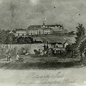
Fernhurst tithe map, c. 1846

![]()
Wall Art and Photo Gifts from West Sussex County Council
Fernhurst tithe map, c. 1846
No date, but Award 1846. Surveyor unknown. 26.6 in to 1 m. 122 × 85
Tithe Award Map Collection
West Sussex Record Office Ref No: TD/W55
West Sussex County Council Record Office contains a fascinating history of the county of West Sussex, England
Media ID 10716325
© West Sussex County Council - All Rights Reserved
1840s 19th Century Historical Mapping South Of England
FEATURES IN THESE COLLECTIONS
> Europe
> United Kingdom
> England
> Maps
> Europe
> United Kingdom
> England
> Sussex
> Fernhurst
> Europe
> United Kingdom
> England
> West Sussex
> Related Images
> Maps and Charts
> Early Maps
> West Sussex County Council
> West Sussex Record Office
> Tithe Award Maps, 1808-1859
EDITORS COMMENTS
This print showcases the Fernhurst tithe map, believed to have been created around 1846. Although the exact date is unknown, it is associated with an award from that year. The surveyor responsible for this remarkable piece of cartography remains a mystery. Measuring at a scale of 26.6 inches to 1 meter, the map spans an impressive area of 122 by 85 units. Part of the esteemed Tithe Award Map Collection housed at West Sussex Record Office, this artifact offers invaluable insights into historical mapping practices during the mid-19th century in southern England. It serves as a testament to the meticulous efforts undertaken by cartographers and land surveyors in documenting land ownership and usage patterns. The Fernhurst tithe map holds immense historical significance, shedding light on how landscapes were divided and managed during this era. Its intricate details provide researchers and history enthusiasts with a window into rural life centuries ago. It is important to note that this caption does not pertain to any specific company or commercial use; rather, it focuses solely on appreciating the cultural heritage preserved within West Sussex County Council's archives. This photograph invites viewers to immerse themselves in a bygone era through its rich visual representation of land boundaries and agricultural practices prevalent in Fernhurst during the mid-19th century.
MADE IN THE UK
Safe Shipping with 30 Day Money Back Guarantee
FREE PERSONALISATION*
We are proud to offer a range of customisation features including Personalised Captions, Color Filters and Picture Zoom Tools
SECURE PAYMENTS
We happily accept a wide range of payment options so you can pay for the things you need in the way that is most convenient for you
* Options may vary by product and licensing agreement. Zoomed Pictures can be adjusted in the Basket.