Antique Framed Print > Europe > Italy > Lazio > Rome
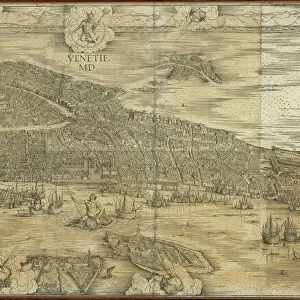
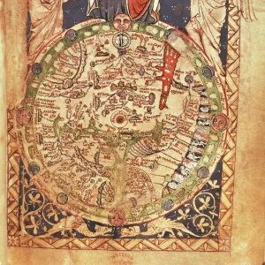
Antique Framed Print : New and Accurate Map of Ancient and Modern Rome by Jean van Ram, copperplate, printed in Amsterdam circa 1691-1693


![]()
Framed Photos from Universal Images Group (UIG)
New and Accurate Map of Ancient and Modern Rome by Jean van Ram, copperplate, printed in Amsterdam circa 1691-1693
Cartography. Italy, 17th century. New and accurate map of Ancient and Modern Rome by Jean van Ram, Amsterdam 1691-1693 ca. Copperplate 50 x 59 cm
Universal Images Group (UIG) manages distribution for many leading specialist agencies worldwide
Media ID 9455199
© DEA PICTURE LIBRARY
17th Century Background People Capital Cities City Cityscape Copperplate Direction Guidance Overhead View Rome Western Script Tiber River
14"x12" (36x31cm) Antique Frame
Bevelled wood effect frame, card mounted, 10x8 archival quality photo print. Overall outside dimensions 14x12 inches (36x31cm). Environmentally and ozone friendly, the Polycore® moulding has the look of real wood, is durable and light and easy to hang. Biodegradable and made with non-chlorinated gases (no toxic fumes) it is efficient; producing 100 tons of polystyrene can save 300 tons of trees! Prints are glazed with lightweight, shatterproof, optical clarity acrylic (providing the same general protection from the environment as glass). The back is stapled hardboard with a sawtooth hanger attached. Note: To minimise original artwork cropping, for optimum layout, and to ensure print is secure, the visible print may be marginally smaller
Bevelled Wood Effect Framed and Mounted Prints - Professionally Made and Ready to Hang
Estimated Image Size (if not cropped) is 24.4cm x 19cm (9.6" x 7.5")
Estimated Product Size is 36.3cm x 31.2cm (14.3" x 12.3")
These are individually made so all sizes are approximate
Artwork printed orientated as per the preview above, with landscape (horizontal) orientation to match the source image.
FEATURES IN THESE COLLECTIONS
> Europe
> Italy
> Lazio
> Rome
> Maps and Charts
> Early Maps
> Maps and Charts
> Italy
> Maps and Charts
> Related Images
> Universal Images Group (UIG)
> Art
> Painting, Sculpture & Prints
> Illustration And Painting
EDITORS COMMENTS
This print showcases a remarkable piece of cartographic history - the "New and Accurate Map of Ancient and Modern Rome" by Jean van Ram. Created in Amsterdam around 1691-1693, this copperplate masterpiece measures an impressive 50 x 59 cm. The map itself offers a fascinating glimpse into the cityscape of Rome during the 17th century. With its overhead view, it presents a comprehensive illustration of both ancient and modern landmarks that make up this iconic capital city. The Tiber River gracefully winds its way through the landscape, adding to the charm and historical significance captured in this artwork. As we delve deeper into the image, we notice background people going about their daily lives, providing a sense of scale and liveliness to this depiction. The attention to detail is truly remarkable; every street, building, and bridge is meticulously rendered with precision. Jean van Ram's expertise shines through his use of Western script on the map's surface. This artistic touch adds an element of elegance to an already visually stunning piece. Whether you are a history enthusiast or simply intrigued by maps as works of art, this print transports you back in time while offering guidance for exploration within Rome's boundaries. It serves as a testament to human curiosity and our desire to understand our surroundings throughout different eras
MADE IN THE UK
Safe Shipping with 30 Day Money Back Guarantee
FREE PERSONALISATION*
We are proud to offer a range of customisation features including Personalised Captions, Color Filters and Picture Zoom Tools
SECURE PAYMENTS
We happily accept a wide range of payment options so you can pay for the things you need in the way that is most convenient for you
* Options may vary by product and licensing agreement. Zoomed Pictures can be adjusted in the Basket.