Antique Framed Print > Europe > United Kingdom > England > Yorkshire > Wadsley Bridge
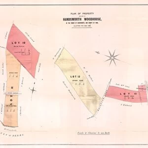
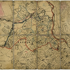
Antique Framed Print : Map of Joseph Machens Farm at Wadsley Bridge, Sheffield, 1790


![]()
Framed Photos from Sheffield City Archives
Map of Joseph Machens Farm at Wadsley Bridge, Sheffield, 1790
Full title: A map of Joseph Machens Farm at Wadsley Bridge held of the Duke of Norfolk with other intermediate lands
Scale 4 chains : 1 inch [20 inches : 1 mile].
Surveyor: William Fairbank II.
Fields, farmstead and a paper mill and dam to the south;
From an original at Sheffield Libraries: arc02621
Sheffield City Archives and Local Studies Library has an unrivalled collection of images of Sheffield, England
Media ID 18127443
© Sheffield City Council - All Rights Reserved
14"x12" (36x31cm) Antique Frame
Bevelled wood effect frame, card mounted, 10x8 archival quality photo print. Overall outside dimensions 14x12 inches (36x31cm). Environmentally and ozone friendly, the Polycore® moulding has the look of real wood, is durable and light and easy to hang. Biodegradable and made with non-chlorinated gases (no toxic fumes) it is efficient; producing 100 tons of polystyrene can save 300 tons of trees! Prints are glazed with lightweight, shatterproof, optical clarity acrylic (providing the same general protection from the environment as glass). The back is stapled hardboard with a sawtooth hanger attached. Note: To minimise original artwork cropping, for optimum layout, and to ensure print is secure, the visible print may be marginally smaller
Bevelled Wood Effect Framed and Mounted Prints - Professionally Made and Ready to Hang
Estimated Image Size (if not cropped) is 18.3cm x 24.4cm (7.2" x 9.6")
Estimated Product Size is 31.2cm x 36.3cm (12.3" x 14.3")
These are individually made so all sizes are approximate
Artwork printed orientated as per the preview above, with portrait (vertical) orientation to match the source image.
FEATURES IN THESE COLLECTIONS
> Europe
> United Kingdom
> England
> Norfolk
> Related Images
> Europe
> United Kingdom
> England
> South Yorkshire
> Related Images
> Europe
> United Kingdom
> England
> South Yorkshire
> Sheffield
> Europe
> United Kingdom
> England
> Yorkshire
> Related Images
> Europe
> United Kingdom
> England
> Yorkshire
> Sheffield
> Europe
> United Kingdom
> England
> Yorkshire
> Wadsley Bridge
> Maps and Charts
> Related Images
> Sheffield City Archives
> Maps and Plans
EDITORS COMMENTS
This print showcases the historical significance of Joseph Machens Farm at Wadsley Bridge in Sheffield, dating back to 1790. The detailed map, titled "A map of Joseph Machens Farm at Wadsley Bridge held of the Duke of Norfolk with other intermediate lands" provides a fascinating glimpse into the past. Surveyed by William Fairbank II, this meticulously crafted map offers a scale of 4 chains to 1 inch or 20 inches to 1 mile. It beautifully depicts the sprawling fields, farmsteads, and even a paper mill and dam located towards the south. These elements highlight not only the agricultural importance but also industrial activities that shaped this area during that era. Preserved within Sheffield Libraries' archives (arc02621), this remarkable piece serves as an invaluable resource for historians and enthusiasts alike. Its depiction sheds light on how Wadsley Bridge evolved over time and its connection to the River Don. As you admire this photo print, take a moment to appreciate its historical significance and imagine life on Joseph Machens Farm centuries ago. Let it transport you back in time when farming was central to daily life in Yorkshire's vibrant city - Sheffield
MADE IN THE UK
Safe Shipping with 30 Day Money Back Guarantee
FREE PERSONALISATION*
We are proud to offer a range of customisation features including Personalised Captions, Color Filters and Picture Zoom Tools
SECURE PAYMENTS
We happily accept a wide range of payment options so you can pay for the things you need in the way that is most convenient for you
* Options may vary by product and licensing agreement. Zoomed Pictures can be adjusted in the Basket.