Antique Framed Print > North Wind Picture Archives > Maps
Antique Framed Print : GMDE2A-00054


![]()
Framed Photos from North Wind
GMDE2A-00054
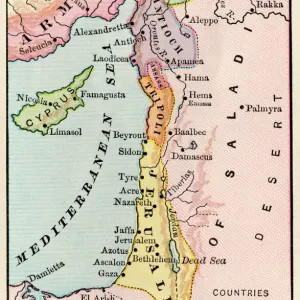
Map of Arabia, 1870s.
Printed color lithograph, 19th century
North Wind Picture Archives brings history to life with stock images and hand-colored illustrations
Media ID 5882247
© North Wind Picture Archives
1870s Arab Arabia Mid East Middle East Territory Arabian Peninsula Gulf Of Aden Persian Gulf Red Sea
14"x12" (36x31cm) Antique Frame
Bevelled wood effect frame, card mounted, 10x8 archival quality photo print. Overall outside dimensions 14x12 inches (36x31cm). Environmentally and ozone friendly, the Polycore® moulding has the look of real wood, is durable and light and easy to hang. Biodegradable and made with non-chlorinated gases (no toxic fumes) it is efficient; producing 100 tons of polystyrene can save 300 tons of trees! Prints are glazed with lightweight, shatterproof, optical clarity acrylic (providing the same general protection from the environment as glass). The back is stapled hardboard with a sawtooth hanger attached. Note: To minimise original artwork cropping, for optimum layout, and to ensure print is secure, the visible print may be marginally smaller
Bevelled Wood Effect Framed and Mounted Prints - Professionally Made and Ready to Hang
Estimated Image Size (if not cropped) is 19.3cm x 24.4cm (7.6" x 9.6")
Estimated Product Size is 31.2cm x 36.3cm (12.3" x 14.3")
These are individually made so all sizes are approximate
Artwork printed orientated as per the preview above, with portrait (vertical) orientation to match the source image.
FEATURES IN THESE COLLECTIONS
> Maps and Charts
> Related Images
> North Wind Picture Archives
> Maps
> North Wind Picture Archives
> Mideast history
EDITORS COMMENTS
This vintage print, titled "GMDE2A-00054 (Map of Arabia, 1870s)" takes us on a journey back to the 19th century. With its traditional and historic allure, this illustration serves as a captivating window into the past. The map showcases the intricate details of the Arabian Peninsula, revealing its vast territory and rich history. The vibrant printed color lithograph brings to life the Middle East's enchanting landscapes and ancient landmarks. From the Red Sea to the Persian Gulf, every contour is meticulously depicted with artistic finesse. This artwork encapsulates not only geographical accuracy but also cultural significance. As we delve deeper into this mesmerizing piece, we are transported through time to an era when exploration was at its peak. The Gulf of Aden sparkles under our gaze while evoking tales of maritime adventures that once unfolded in these waters. Beyond being a mere map, this artful creation embodies an amalgamation of historical documentation and aesthetic beauty. Its portrayal of Arabia in the 1870s offers us glimpses into how borders were defined during that period and provides valuable insights into geopolitical dynamics. Whether you are an art enthusiast or a history buff, this exquisite print from North Wind Picture Archives will undoubtedly captivate your imagination with its intricate detailing and evoke curiosity about bygone times in one of the world's most fascinating regions - Arabia.
MADE IN THE UK
Safe Shipping with 30 Day Money Back Guarantee
FREE PERSONALISATION*
We are proud to offer a range of customisation features including Personalised Captions, Color Filters and Picture Zoom Tools
SECURE PAYMENTS
We happily accept a wide range of payment options so you can pay for the things you need in the way that is most convenient for you
* Options may vary by product and licensing agreement. Zoomed Pictures can be adjusted in the Basket.