Antique Framed Print > Maps and Charts > Americas
Antique Framed Print : EVCW2A-00100


![]()
Framed Photos from North Wind
EVCW2A-00100
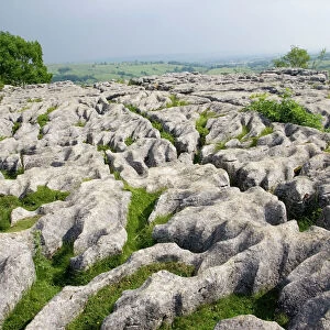
US map showing seceding states by date, American Civil War, 1860 and 1861.
Printed color lithograph 19th century
North Wind Picture Archives brings history to life with stock images and hand-colored illustrations
Media ID 5879658
© North Wind Picture Archives
1860 1860s Civil War Confederacy Confederate Rebellion Secession South Southern State States Territory
14"x12" (36x31cm) Antique Frame
Bevelled wood effect frame, card mounted, 10x8 archival quality photo print. Overall outside dimensions 14x12 inches (36x31cm). Environmentally and ozone friendly, the Polycore® moulding has the look of real wood, is durable and light and easy to hang. Biodegradable and made with non-chlorinated gases (no toxic fumes) it is efficient; producing 100 tons of polystyrene can save 300 tons of trees! Prints are glazed with lightweight, shatterproof, optical clarity acrylic (providing the same general protection from the environment as glass). The back is stapled hardboard with a sawtooth hanger attached. Note: To minimise original artwork cropping, for optimum layout, and to ensure print is secure, the visible print may be marginally smaller
Bevelled Wood Effect Framed and Mounted Prints - Professionally Made and Ready to Hang
Estimated Image Size (if not cropped) is 24.4cm x 16.9cm (9.6" x 6.7")
Estimated Product Size is 36.3cm x 31.2cm (14.3" x 12.3")
These are individually made so all sizes are approximate
Artwork printed orientated as per the preview above, with landscape (horizontal) orientation to match the source image.
FEATURES IN THESE COLLECTIONS
> Maps and Charts
> Related Images
> North America
> Related Images
> South America
> Related Images
> North Wind Picture Archives
> Civil War (US)
> North Wind Picture Archives
> Maps
EDITORS COMMENTS
This vintage print showcases a significant moment in American history - the secession of states during the American Civil War. Titled "EVCW2A-00100" this printed color lithograph from the 19th century provides a visual representation of the seceding states by date, specifically focusing on the years 1860 and 1861. The artwork depicts a map of the United States, highlighting various southern states that chose to rebel against the Union during this tumultuous period. The vibrant colors bring life to this historic illustration, allowing viewers to immerse themselves in an era filled with rebellion and conflict. As one gazes upon this piece, it becomes evident how deeply divided America was at that time. The Confederate territory is clearly demarcated, representing those regions that sought independence from the rest of the country. This print serves as a reminder of both our nation's past struggles and its resilience in overcoming such challenges. With its intricate details and artistic flair, this 19th-century lithograph captures not only historical accuracy but also evokes emotions tied to patriotism and unity. It stands as a testament to our shared heritage while reminding us never to forget or repeat such divisive moments in our collective history
MADE IN THE UK
Safe Shipping with 30 Day Money Back Guarantee
FREE PERSONALISATION*
We are proud to offer a range of customisation features including Personalised Captions, Color Filters and Picture Zoom Tools
SECURE PAYMENTS
We happily accept a wide range of payment options so you can pay for the things you need in the way that is most convenient for you
* Options may vary by product and licensing agreement. Zoomed Pictures can be adjusted in the Basket.