Antique Framed Print > Arts > Artists > W > Frederick de Wit
Antique Framed Print : Map Frederick de Wit 1610-1698 Copperplate print


![]()
Framed Photos from Liszt Collection
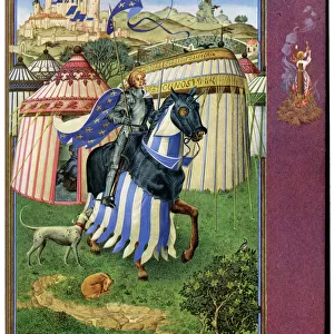
Map Frederick de Wit 1610-1698 Copperplate print
Map, Frederick de Wit (1610-1698), Copperplate print
Liszt Collection of nineteenth-century engravings and images to browse and enjoy
Media ID 19585814
© Artokoloro
1610 1698 Copperplate Print Frederick De Wit
14"x12" (36x31cm) Antique Frame
Bevelled wood effect frame, card mounted, 10x8 archival quality photo print. Overall outside dimensions 14x12 inches (36x31cm). Environmentally and ozone friendly, the Polycore® moulding has the look of real wood, is durable and light and easy to hang. Biodegradable and made with non-chlorinated gases (no toxic fumes) it is efficient; producing 100 tons of polystyrene can save 300 tons of trees! Prints are glazed with lightweight, shatterproof, optical clarity acrylic (providing the same general protection from the environment as glass). The back is stapled hardboard with a sawtooth hanger attached. Note: To minimise original artwork cropping, for optimum layout, and to ensure print is secure, the visible print may be marginally smaller
Bevelled Wood Effect Framed and Mounted Prints - Professionally Made and Ready to Hang
Estimated Image Size (if not cropped) is 24.4cm x 19.4cm (9.6" x 7.6")
Estimated Product Size is 36.3cm x 31.2cm (14.3" x 12.3")
These are individually made so all sizes are approximate
Artwork printed orientated as per the preview above, with landscape (horizontal) orientation to match the source image.
FEATURES IN THESE COLLECTIONS
> Arts
> Artists
> W
> Frederick de Wit
> Maps and Charts
> Related Images
EDITORS COMMENTS
This print showcases the remarkable work of Frederick de Wit, a renowned cartographer from the 17th century. The intricate details and exquisite craftsmanship of this copperplate print are truly awe-inspiring. De Wit's mastery in mapmaking is evident in this particular piece, which dates back to the years between 1610 and 1698. The map itself is a testament to his dedication and skill, as it beautifully depicts various regions with utmost precision. The Liszt Collection has done an exceptional job capturing every minute detail of this historical artifact through their high-quality photo print. From the delicate lines that outline coastlines and rivers to the meticulously drawn borders of countries and continents, every element comes alive on paper. As we gaze upon this magnificent artwork, we are transported back in time to an era when exploration was at its peak. This map serves as a window into history, allowing us to marvel at how our understanding of geography has evolved over centuries. While it is important not to mention commercial use or confuse it with any company bearing a similar name, let us appreciate this print for what it truly represents: a tangible piece of art that encapsulates both historical significance and artistic brilliance.
MADE IN THE UK
Safe Shipping with 30 Day Money Back Guarantee
FREE PERSONALISATION*
We are proud to offer a range of customisation features including Personalised Captions, Color Filters and Picture Zoom Tools
SECURE PAYMENTS
We happily accept a wide range of payment options so you can pay for the things you need in the way that is most convenient for you
* Options may vary by product and licensing agreement. Zoomed Pictures can be adjusted in the Basket.