Antique Framed Print > Maps and Charts > Germany
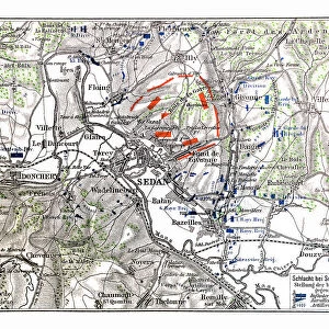
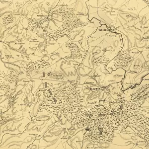
Antique Framed Print : Franco-Prussian War: Map of Alsace and Lorraine, Counties Given to the German Empire 1870


![]()
Framed Photos from Liszt Collection
Franco-Prussian War: Map of Alsace and Lorraine, Counties Given to the German Empire 1870
Liszt Collection of nineteenth-century engravings and images to browse and enjoy
Media ID 12825293
© Quint Lox Limited
Alsace Empire Franco Prussian War Lorraine Counties
21"x16" (54x41cm) Antique Frame
Bevelled wood effect frame, card mounted, 15x10 archival quality photo print. Overall outside dimensions 21x16 inches (54x41cm). Environmentally and ozone friendly, Polycore® moulding has the look of real wood, is durable and light and easy to hang. Biodegradable and made with non-chlorinated gases (no toxic fumes) it is efficient; producing 100 tons of polystyrene can save 300 tons of trees! Prints are glazed with lightweight, shatterproof, optical clarity acrylic (providing the same general protection from the environment as glass). The back is stapled hardboard with a sawtooth hanger attached. Note: To minimise original artwork cropping, for optimum layout, and to ensure print is secure, the visible print may be marginally smaller
Bevelled Wood Effect Framed and Mounted Prints - Professionally Made and Ready to Hang
Estimated Image Size (if not cropped) is 24.9cm x 37.1cm (9.8" x 14.6")
Estimated Product Size is 41.4cm x 54cm (16.3" x 21.3")
These are individually made so all sizes are approximate
Artwork printed orientated as per the preview above, with portrait (vertical) orientation to match the source image.
FEATURES IN THESE COLLECTIONS
> Maps and Charts
> Related Images
EDITORS COMMENTS
This print showcases a historical map of Alsace and Lorraine, two counties that were given to the German Empire during the Franco-Prussian War in 1870. The intricate engravement technique used to create this image transports us back to the 19th century, immersing us in its Victorian charm. With its vintage and retro style, this piece of historic art from Arkheia evokes a sense of nostalgia for a bygone era. The map itself is meticulously detailed, highlighting the borders and topography of Alsace and Lorraine with precision. It serves as a visual representation of the territorial changes that occurred during one of Europe's most significant conflicts. As we gaze upon this engraving, we are reminded of the cultural impact such events had on nations involved. Through this print, we gain insight into not only the military aspects but also how history intertwines with arts and culture. Its presence reminds us that even in times marked by conflict, there is beauty to be found in illustrative techniques like engravings. As we reflect on this historical artifact from the Liszt Collection, it prompts us to contemplate how our world has evolved since those tumultuous times. This image serves as both an educational tool and a testament to human resilience throughout history.
MADE IN THE UK
Safe Shipping with 30 Day Money Back Guarantee
FREE PERSONALISATION*
We are proud to offer a range of customisation features including Personalised Captions, Color Filters and Picture Zoom Tools
SECURE PAYMENTS
We happily accept a wide range of payment options so you can pay for the things you need in the way that is most convenient for you
* Options may vary by product and licensing agreement. Zoomed Pictures can be adjusted in the Basket.