Antique Framed Print > Arts > Artists > O > Oceanic Oceanic
Antique Framed Print : Map of the Indian Ocean


![]()
Framed Photos from Heritage Images
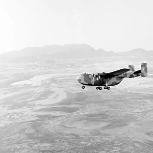
Map of the Indian Ocean
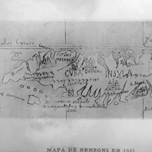
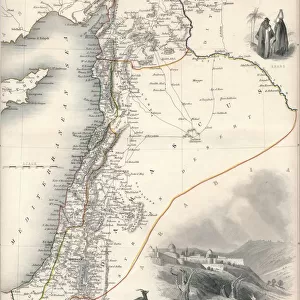
Map of the Indian Ocean. Map showing the Indian subcontinent, East Africa, the Arabian peninsula, Indo-China and Western Australia. Plate 54 from The Times Atlas
Heritage Images features heritage image collections
Media ID 15464866
© The Print Collector / Heritage-Images
Australia Cartography Coastline East Africa Indian Ocean Indochina Madagascar Map Making Oceania Saudi Arabia
14"x12" (36x31cm) Antique Frame
Bevelled wood effect frame, card mounted, 10x8 archival quality photo print. Overall outside dimensions 14x12 inches (36x31cm). Environmentally and ozone friendly, the Polycore® moulding has the look of real wood, is durable and light and easy to hang. Biodegradable and made with non-chlorinated gases (no toxic fumes) it is efficient; producing 100 tons of polystyrene can save 300 tons of trees! Prints are glazed with lightweight, shatterproof, optical clarity acrylic (providing the same general protection from the environment as glass). The back is stapled hardboard with a sawtooth hanger attached. Note: To minimise original artwork cropping, for optimum layout, and to ensure print is secure, the visible print may be marginally smaller
Bevelled Wood Effect Framed and Mounted Prints - Professionally Made and Ready to Hang
Estimated Image Size (if not cropped) is 24.4cm x 18.8cm (9.6" x 7.4")
Estimated Product Size is 36.3cm x 31.2cm (14.3" x 12.3")
These are individually made so all sizes are approximate
Artwork printed orientated as per the preview above, with landscape (horizontal) orientation to match the source image.
FEATURES IN THESE COLLECTIONS
> Africa
> Madagascar
> Maps
> Africa
> Madagascar
> Related Images
> Arts
> Artists
> O
> Oceanic Oceanic
> Asia
> India
> Related Images
> Asia
> Saudi Arabia
> Maps
> Asia
> Saudi Arabia
> Related Images
EDITORS COMMENTS
This print showcases a historical treasure, the "Map of the Indian Ocean". With intricate details and vibrant colors, this map offers a glimpse into the past, revealing the geographical features of the Indian subcontinent, East Africa, Arabian Peninsula, Indo-China, and Western Australia. Plate 54 from The Times Atlas captures these regions with precision and artistry. As we delve into this map's beauty and significance, we are transported to an era when cartography was both science and art. Every coastline is meticulously outlined in stunning color hues that bring life to each landmass. From India's majestic shores to Madagascar's enchanting coastlines - all are depicted with utmost accuracy. The Indian Ocean takes center stage on this remarkable piece. Its vastness is beautifully portrayed as it connects different continents through its azure waters. This map serves as a testament to human curiosity about our planet's diverse landscapes. With every glance at this print, one can't help but marvel at how far our understanding of geography has come since its creation. It reminds us of the explorers who ventured across these lands centuries ago in search of new horizons. Preserved by The Print Collector for future generations to appreciate and learn from, this Map of the Indian Ocean holds immense historical value. It stands as a testament to mankind's unending quest for knowledge about our world – an enduring symbol of discovery and exploration.
MADE IN THE UK
Safe Shipping with 30 Day Money Back Guarantee
FREE PERSONALISATION*
We are proud to offer a range of customisation features including Personalised Captions, Color Filters and Picture Zoom Tools
SECURE PAYMENTS
We happily accept a wide range of payment options so you can pay for the things you need in the way that is most convenient for you
* Options may vary by product and licensing agreement. Zoomed Pictures can be adjusted in the Basket.