Antique Framed Print > North America > United States of America > Washington > Vancouver
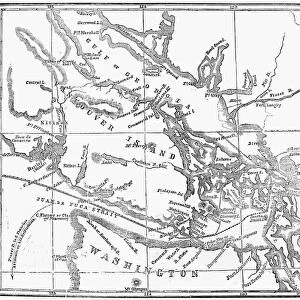
Antique Framed Print : MAP: VANCOUVER ISLAND, 1859. Map of Vancouver Island and Washington Territory


![]()
Framed Photos from Granger
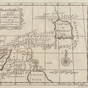
MAP: VANCOUVER ISLAND, 1859. Map of Vancouver Island and Washington Territory
MAP: VANCOUVER ISLAND, 1859.
Map of Vancouver Island and Washington Territory, shwoing San Juan Island and the disputed territory. Map, 1859
Granger holds millions of images spanning more than 25,000 years of world history, from before the Stone Age to the dawn of the Space Age
Media ID 12321287
1859 Canadian Territory United States Vancouver Island Washington Gulf Of Georgia San Juan Island
14"x12" (36x31cm) Antique Frame
Bevelled wood effect frame, card mounted, 10x8 archival quality photo print. Overall outside dimensions 14x12 inches (36x31cm). Environmentally and ozone friendly, the Polycore® moulding has the look of real wood, is durable and light and easy to hang. Biodegradable and made with non-chlorinated gases (no toxic fumes) it is efficient; producing 100 tons of polystyrene can save 300 tons of trees! Prints are glazed with lightweight, shatterproof, optical clarity acrylic (providing the same general protection from the environment as glass). The back is stapled hardboard with a sawtooth hanger attached. Note: To minimise original artwork cropping, for optimum layout, and to ensure print is secure, the visible print may be marginally smaller
Bevelled Wood Effect Framed and Mounted Prints - Professionally Made and Ready to Hang
Estimated Image Size (if not cropped) is 24.4cm x 18.4cm (9.6" x 7.2")
Estimated Product Size is 36.3cm x 31.2cm (14.3" x 12.3")
These are individually made so all sizes are approximate
Artwork printed orientated as per the preview above, with landscape (horizontal) orientation to match the source image.
FEATURES IN THESE COLLECTIONS
> Asia
> Georgia
> Related Images
> Maps and Charts
> Related Images
> North America
> Canada
> Maps
> North America
> Canada
> Related Images
> North America
> Canada
> Vancouver
> North America
> United States of America
> Washington
> Vancouver
> Granger Art on Demand
> Maps
MAP - VANCOUVER ISLAND, 1859. A Glimpse into the Historical Borders and Disputes of Vancouver Island and Washington Territory
EDITORS COMMENTS
. This print takes us back to the year 1859, where a meticulously detailed map showcases the intricate borders between Vancouver Island and Washington Territory. The engraving, skillfully crafted by Granger in NYC, offers a fascinating insight into the historical dynamics of this region. The map highlights not only Vancouver Island's geographical features but also sheds light on San Juan Island - an area that was fiercely contested between Canada and the United States during this time. This disputed territory is clearly marked, serving as a reminder of past conflicts that shaped both American and Canadian history. As we delve deeper into this visual treasure trove, it becomes evident how crucial these boundaries were for defining national identities. The Gulf of Georgia acts as a natural divider between these two territories while emphasizing their interconnectedness through trade routes and maritime activities. Granger Art on Demand has masterfully preserved this piece from 1859, allowing us to appreciate its historical significance today. Whether you are an avid historian or simply intrigued by cartography, this print serves as a window into America's past - capturing an era when borders were being defined amidst political tensions.
MADE IN THE UK
Safe Shipping with 30 Day Money Back Guarantee
FREE PERSONALISATION*
We are proud to offer a range of customisation features including Personalised Captions, Color Filters and Picture Zoom Tools
SECURE PAYMENTS
We happily accept a wide range of payment options so you can pay for the things you need in the way that is most convenient for you
* Options may vary by product and licensing agreement. Zoomed Pictures can be adjusted in the Basket.