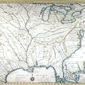
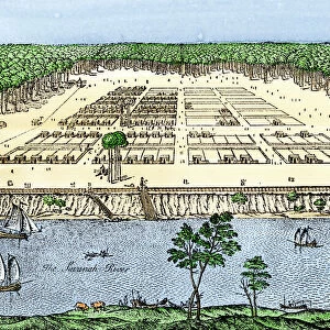
Antique Framed Print > Arts > Landscape paintings > Waterfall and river artworks > River artworks
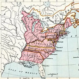
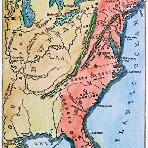
Antique Framed Print : COLONIAL AMERICA MAP. A map of the thirteen original American colonies, mid-18th century. Line engraving, late 19th century


![]()
Framed Photos from Granger
COLONIAL AMERICA MAP. A map of the thirteen original American colonies, mid-18th century. Line engraving, late 19th century
Granger holds millions of images spanning more than 25,000 years of world history, from before the Stone Age to the dawn of the Space Age
Media ID 7506727
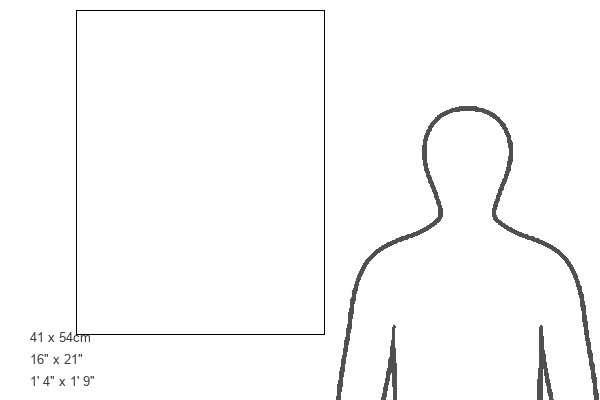
21"x16" (54x41cm) Antique Frame
Bevelled wood effect frame, card mounted, 15x10 archival quality photo print. Overall outside dimensions 21x16 inches (54x41cm). Environmentally and ozone friendly, Polycore® moulding has the look of real wood, is durable and light and easy to hang. Biodegradable and made with non-chlorinated gases (no toxic fumes) it is efficient; producing 100 tons of polystyrene can save 300 tons of trees! Prints are glazed with lightweight, shatterproof, optical clarity acrylic (providing the same general protection from the environment as glass). The back is stapled hardboard with a sawtooth hanger attached. Note: To minimise original artwork cropping, for optimum layout, and to ensure print is secure, the visible print may be marginally smaller
Bevelled Wood Effect Framed and Mounted Prints - Professionally Made and Ready to Hang
Estimated Image Size (if not cropped) is 23.1cm x 37.1cm (9.1" x 14.6")
Estimated Product Size is 41.4cm x 54cm (16.3" x 21.3")
These are individually made so all sizes are approximate
Artwork printed orientated as per the preview above, with portrait (vertical) orientation to match the source image.
FEATURES IN THESE COLLECTIONS
> Arts
> Landscape paintings
> Waterfall and river artworks
> River artworks
> Historic
> Colonial America illustrations
> 18th century America
> Historic
> Colonial America illustrations
> American colonies
> Historic
> Colonial America illustrations
> Colonial America
> Maps and Charts
> Related Images
> Granger Art on Demand
> Maps
EDITORS COMMENTS
This print showcases a historical treasure - the Colonial America Map. Created in the mid-18th century, this line engraving from the late 19th century offers a glimpse into the thirteen original American colonies that laid the foundation for modern-day United States. The intricate details and craftsmanship of this map are truly remarkable. As we explore this piece, we are transported back in time to an era when America was still emerging as a nation. The map highlights major rivers that played crucial roles in shaping early settlements and trade routes across these colonies. It serves as a testament to the adventurous spirit and determination of those who ventured into uncharted territories. The Granger Collection has expertly preserved this invaluable artifact, allowing us to appreciate its historical significance today. This print is not just an artwork; it is a window into our past, reminding us of our roots and how far we have come as a nation. Whether you are an avid history enthusiast or simply curious about America's colonial heritage, this print will undoubtedly captivate your imagination. Display it proudly on your wall or use it as an educational tool to spark conversations about our rich cultural heritage with friends and family. Join us on a journey through time with this extraordinary Colonial America Map from Granger Art on Demand!
MADE IN THE UK
Safe Shipping with 30 Day Money Back Guarantee
FREE PERSONALISATION*
We are proud to offer a range of customisation features including Personalised Captions, Color Filters and Picture Zoom Tools
SECURE PAYMENTS
We happily accept a wide range of payment options so you can pay for the things you need in the way that is most convenient for you
* Options may vary by product and licensing agreement. Zoomed Pictures can be adjusted in the Basket.