Antique Framed Print > Fine Art Storehouse > Photo Libraries > Dorling Kindersley Prints
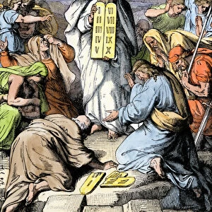
Antique Framed Print : Illustrated maps of ancient Canaan (left) and Sinai peninsula (right)
 and Sinai peninsula (right)")
 and Sinai peninsula (right)")


![]()
Framed Photos from Fine Art Storehouse
Illustrated maps of ancient Canaan (left) and Sinai peninsula (right)
Unleash your creativity and transform your space into a visual masterpiece!
Dorling Kindersley
Media ID 13540767
© This content is subject to copyright
Ancient Civilisations Ancient History Background People Canaan Empire Geography Illustrated Map Incidental People Israel Judaism Large Group Of People Middle East Old Testament Sinai Sinai Egypt Watercolour Painting
21"x16" (54x41cm) Antique Frame
Bevelled wood effect frame, card mounted, 15x10 archival quality photo print. Overall outside dimensions 21x16 inches (54x41cm). Environmentally and ozone friendly, Polycore® moulding has the look of real wood, is durable and light and easy to hang. Biodegradable and made with non-chlorinated gases (no toxic fumes) it is efficient; producing 100 tons of polystyrene can save 300 tons of trees! Prints are glazed with lightweight, shatterproof, optical clarity acrylic (providing the same general protection from the environment as glass). The back is stapled hardboard with a sawtooth hanger attached. Note: To minimise original artwork cropping, for optimum layout, and to ensure print is secure, the visible print may be marginally smaller
Bevelled Wood Effect Framed and Mounted Prints - Professionally Made and Ready to Hang
Estimated Image Size (if not cropped) is 37.1cm x 24.7cm (14.6" x 9.7")
Estimated Product Size is 54cm x 41.4cm (21.3" x 16.3")
These are individually made so all sizes are approximate
Artwork printed orientated as per the preview above, with landscape (horizontal) orientation to match the source image.
FEATURES IN THESE COLLECTIONS
> Fine Art Storehouse
> Photo Libraries
> Dorling Kindersley Prints
> Fine Art Storehouse
> World Religion
EDITORS COMMENTS
This print showcases the beautifully illustrated maps of ancient Canaan and the Sinai Peninsula. On the left, we are transported back in time to explore the intricate details of Canaan, an empire steeped in rich history and culture. The map vividly depicts its geography, with rolling hills, rivers meandering through lush valleys, and cities bustling with life. It serves as a window into a bygone era when ancient civilizations thrived. On the right side of this enchanting print lies the Sinai Peninsula, a land shrouded in mystery and religious significance. The illustration transports us to this sacred region where Judaism flourished and biblical stories unfolded. With its rugged mountains, vast deserts stretching endlessly towards distant horizons, and oases providing respite from harsh conditions, it is no wonder that this land holds immense spiritual importance. The watercolor paintings on both maps bring these ancient lands to life with their vibrant colors and meticulous attention to detail. Against a clean white background, they serve as visual reminders of our connection to the past. This studio shot captures not only these remarkable illustrations but also hints at the presence of people who have dedicated themselves to studying ancient history. As we gaze upon this print by Dorling Kindersley from Fine Art Storehouse, we are reminded of how art can transport us across time and space while igniting our curiosity about those who came before us.
MADE IN THE UK
Safe Shipping with 30 Day Money Back Guarantee
FREE PERSONALISATION*
We are proud to offer a range of customisation features including Personalised Captions, Color Filters and Picture Zoom Tools
SECURE PAYMENTS
We happily accept a wide range of payment options so you can pay for the things you need in the way that is most convenient for you
* Options may vary by product and licensing agreement. Zoomed Pictures can be adjusted in the Basket.