Antique Framed Print > Europe > Italy > Maps
Antique Framed Print : Antique colored illustrations: Geological map of England and Wales


![]()
Framed Photos from Fine Art Storehouse
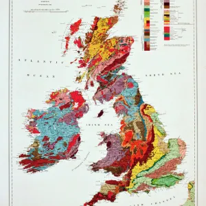
Antique colored illustrations: Geological map of England and Wales
Unleash your creativity and transform your space into a visual masterpiece!
ilbusca
Media ID 13609177
© This content is subject to copyright
Colors Geology Layered Painting Sketch Wales Drawing Art Product Geologic Time Scale Retro Styled Stone Material Victorian Style
14"x12" (36x31cm) Antique Frame
Bevelled wood effect frame, card mounted, 10x8 archival quality photo print. Overall outside dimensions 14x12 inches (36x31cm). Environmentally and ozone friendly, the Polycore® moulding has the look of real wood, is durable and light and easy to hang. Biodegradable and made with non-chlorinated gases (no toxic fumes) it is efficient; producing 100 tons of polystyrene can save 300 tons of trees! Prints are glazed with lightweight, shatterproof, optical clarity acrylic (providing the same general protection from the environment as glass). The back is stapled hardboard with a sawtooth hanger attached. Note: To minimise original artwork cropping, for optimum layout, and to ensure print is secure, the visible print may be marginally smaller
Bevelled Wood Effect Framed and Mounted Prints - Professionally Made and Ready to Hang
Estimated Image Size (if not cropped) is 17.4cm x 24.4cm (6.9" x 9.6")
Estimated Product Size is 31.2cm x 36.3cm (12.3" x 14.3")
These are individually made so all sizes are approximate
Artwork printed orientated as per the preview above, with portrait (vertical) orientation to match the source image.
FEATURES IN THESE COLLECTIONS
> Europe
> Italy
> Related Images
> Europe
> United Kingdom
> England
> Maps
> Europe
> United Kingdom
> England
> Paintings
> Europe
> United Kingdom
> England
> Posters
> Europe
> United Kingdom
> England
> Related Images
> Europe
> United Kingdom
> Maps
> Europe
> United Kingdom
> Paintings
> Fine Art Storehouse
> Map
> Historical Maps
> Fine Art Storehouse
> Map
> Italian Maps
EDITORS COMMENTS
This print takes us on a journey back in time to the 19th century, immersing us in the rich history and geological wonders of England and Wales. The antique colored illustrations beautifully depict a detailed map, showcasing the diverse landscapes and intricate layers of stone that make up these regions. The retro-styled image exudes an air of nostalgia, transporting us to a bygone era when hand-drawn engravings were meticulously crafted with Victorian precision. Each stroke of the artist's pen brings forth a sense of artistry and dedication that is rarely seen in today's digital age. As we gaze upon this archival masterpiece, we are reminded of the importance of understanding our planet's past. The geologic time scale depicted on this map serves as a visual reminder of how Earth has evolved over millions of years. The vibrant colors used in this illustration breathe life into each contour and formation, allowing us to appreciate not only its scientific value but also its aesthetic appeal. This print effortlessly combines science and art, merging geology with painting to create something truly remarkable. Whether you are an avid collector or simply intrigued by history, this antique print will transport you back in time while igniting your curiosity about the geological wonders that lie beneath our feet.
MADE IN THE UK
Safe Shipping with 30 Day Money Back Guarantee
FREE PERSONALISATION*
We are proud to offer a range of customisation features including Personalised Captions, Color Filters and Picture Zoom Tools
SECURE PAYMENTS
We happily accept a wide range of payment options so you can pay for the things you need in the way that is most convenient for you
* Options may vary by product and licensing agreement. Zoomed Pictures can be adjusted in the Basket.