Antique Framed Print > Arts > Photorealistic artworks > Detailed art pieces > Masterful detailing in art
Antique Framed Print : Ireland Vector Map


![]()
Framed Photos from Fine Art Storehouse
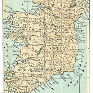
Ireland Vector Map
Highly detailed vector map of the Republic of Ireland. File was created on June 24, 2011. The colors in the.eps-file are ready for print (CMYK). Included files: EPS (v8) and Hi-Res JPG
Unleash your creativity and transform your space into a visual masterpiece!
Media ID 14833465
18"x18" (46x46cm) Antique Frame
Bevelled wood effect frame, card mounted, 12x12 archival quality photo print. Overall outside dimensions 18x18 inches (46x46cm). Environmentally and ozone friendly, Polycore® moulding has the look of real wood, is durable and light and easy to hang. Biodegradable and made with non-chlorinated gases (no toxic fumes) it is efficient; producing 100 tons of polystyrene can save 300 tons of trees! Prints are glazed with lightweight, shatterproof, optical clarity acrylic (providing the same general protection from the environment as glass). The back is stapled hardboard with a sawtooth hanger attached. Note: To minimise original artwork cropping, for optimum layout, and to ensure print is secure, the visible print may be marginally smaller
Bevelled Wood Effect Framed and Mounted Prints - Professionally Made and Ready to Hang
Estimated Image Size (if not cropped) is 29.4cm x 29.4cm (11.6" x 11.6")
Estimated Product Size is 46.5cm x 46.5cm (18.3" x 18.3")
These are individually made so all sizes are approximate
Artwork printed orientated as per the preview above, with landscape (horizontal) or portrait (vertical) orientation to match the source image.
FEATURES IN THESE COLLECTIONS
> Arts
> Photorealistic artworks
> Detailed art pieces
> Masterful detailing in art
> Europe
> Republic of Ireland
> Maps
> Europe
> Republic of Ireland
> Related Images
> Maps and Charts
> Related Images
> Fine Art Storehouse
> Map
> Map Illustrations
EDITORS COMMENTS
This stunning print showcases the beauty and intricacy of Ireland's geography through a highly detailed vector map. Created on June 24,2011, this file captures the essence of the Republic of Ireland with remarkable precision. The colors in the. eps-file are specifically designed for print using CMYK technology, ensuring vibrant and accurate reproduction. The rich green hues that dominate this map perfectly encapsulate Ireland's lush landscapes and rolling hills. From its rugged coastlines to its charming countryside, every corner of this enchanting island is meticulously depicted in this artwork. Whether you have a deep connection to Ireland or simply appreciate fine cartography, this print is sure to captivate your imagination. Hang it proudly on your wall as a testament to your love for travel or use it as an educational tool to explore the various regions and cities within Ireland. Included in this purchase are both an EPS (v8) file and a high-resolution JPG image, offering flexibility for different printing needs.
MADE IN THE UK
Safe Shipping with 30 Day Money Back Guarantee
FREE PERSONALISATION*
We are proud to offer a range of customisation features including Personalised Captions, Color Filters and Picture Zoom Tools
SECURE PAYMENTS
We happily accept a wide range of payment options so you can pay for the things you need in the way that is most convenient for you
* Options may vary by product and licensing agreement. Zoomed Pictures can be adjusted in the Basket.