Antique Framed Print > Fine Art Storehouse > Map
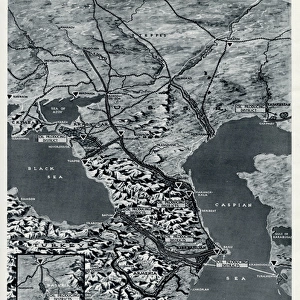
Antique Framed Print : Antique map of Sarmatiam Asiaticam


![]()
Framed Photos from Fine Art Storehouse
Antique map of Sarmatiam Asiaticam
Unleash your creativity and transform your space into a visual masterpiece!
Hemera Technologies
Media ID 13609549
© Getty Images
Black Sea Border Direction Document Former Soviet Union Geography Legend Location Paper Place Positioning Scale Soviet Union Ukraine Sarmatia
14"x12" (36x31cm) Antique Frame
Bevelled wood effect frame, card mounted, 10x8 archival quality photo print. Overall outside dimensions 14x12 inches (36x31cm). Environmentally and ozone friendly, the Polycore® moulding has the look of real wood, is durable and light and easy to hang. Biodegradable and made with non-chlorinated gases (no toxic fumes) it is efficient; producing 100 tons of polystyrene can save 300 tons of trees! Prints are glazed with lightweight, shatterproof, optical clarity acrylic (providing the same general protection from the environment as glass). The back is stapled hardboard with a sawtooth hanger attached. Note: To minimise original artwork cropping, for optimum layout, and to ensure print is secure, the visible print may be marginally smaller
Bevelled Wood Effect Framed and Mounted Prints - Professionally Made and Ready to Hang
Estimated Image Size (if not cropped) is 24.4cm x 19.1cm (9.6" x 7.5")
Estimated Product Size is 36.3cm x 31.2cm (14.3" x 12.3")
These are individually made so all sizes are approximate
Artwork printed orientated as per the preview above, with landscape (horizontal) orientation to match the source image.
FEATURES IN THESE COLLECTIONS
> Fine Art Storehouse
> Map
> Historical Maps
EDITORS COMMENTS
This print showcases an exquisite antique map of Sarmatiam Asiaticam, a region steeped in history and mystery. The map, carefully preserved and archived over the years, offers a glimpse into the cartography of yesteryears. The black sea borders this remarkable piece of artistry, while intricate engravings depict the geography and physical features of Sarmatia. A key and legend provide invaluable information about locations and scales, guiding explorers through this vast expanse. With its horizontal orientation and vibrant colors, this vintage map evokes a sense of nostalgia for a bygone era. Its significance is further heightened as it represents the former Soviet Union's territory, specifically Ukraine. As we gaze upon this historical artifact captured by Hemera Technologies' skilled photography, we are transported back in time to an age when maps were treasured possessions that unlocked new worlds. The absence of people allows us to focus solely on the rich history embedded within these lines and symbols. Whether you are an avid collector or simply appreciate the beauty of antiquity, this print serves as a testament to human curiosity and our innate desire to explore uncharted territories. Let it adorn your walls as a reminder that there is always more to discover beyond what meets the eye.
MADE IN THE UK
Safe Shipping with 30 Day Money Back Guarantee
FREE PERSONALISATION*
We are proud to offer a range of customisation features including Personalised Captions, Color Filters and Picture Zoom Tools
SECURE PAYMENTS
We happily accept a wide range of payment options so you can pay for the things you need in the way that is most convenient for you
* Options may vary by product and licensing agreement. Zoomed Pictures can be adjusted in the Basket.