Antique Framed Print > Fine Art Finder > Artists > Battista Agnese
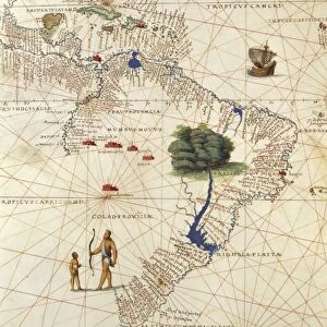
Antique Framed Print : Madagascar, from an Atlas of the World in 33 Maps, Venice, 1st September 1553 (ink on vellum)
")
")


![]()
Framed Photos from Fine Art Finder
Madagascar, from an Atlas of the World in 33 Maps, Venice, 1st September 1553 (ink on vellum)
XOT330957 Madagascar, from an Atlas of the World in 33 Maps, Venice, 1st September 1553 (ink on vellum) (detail from 330955) by Agnese, Battista (1514-64); Museo Correr, Venice, Italy; Italian, out of copyright
Media ID 12852674
© www.bridgemanart.com
Lake Victoria Mapping Nautical Chart Navigation Great Rift Valley
14"x12" (36x31cm) Antique Frame
Bevelled wood effect frame, card mounted, 10x8 archival quality photo print. Overall outside dimensions 14x12 inches (36x31cm). Environmentally and ozone friendly, the Polycore® moulding has the look of real wood, is durable and light and easy to hang. Biodegradable and made with non-chlorinated gases (no toxic fumes) it is efficient; producing 100 tons of polystyrene can save 300 tons of trees! Prints are glazed with lightweight, shatterproof, optical clarity acrylic (providing the same general protection from the environment as glass). The back is stapled hardboard with a sawtooth hanger attached. Note: To minimise original artwork cropping, for optimum layout, and to ensure print is secure, the visible print may be marginally smaller
Bevelled Wood Effect Framed and Mounted Prints - Professionally Made and Ready to Hang
Estimated Image Size (if not cropped) is 24.4cm x 19.3cm (9.6" x 7.6")
Estimated Product Size is 36.3cm x 31.2cm (14.3" x 12.3")
These are individually made so all sizes are approximate
Artwork printed orientated as per the preview above, with landscape (horizontal) orientation to match the source image.
FEATURES IN THESE COLLECTIONS
> Fine Art Finder
> Artists
> Battista Agnese
> Fine Art Finder
> Maps (celestial & Terrestrial)
EDITORS COMMENTS
This print showcases a detailed map of Madagascar, extracted from an extraordinary Atlas of the World in 33 Maps. Created by the skilled Italian cartographer Battista Agnese on September 1st, 1553, this ink on vellum masterpiece is now housed at the Museo Correr in Venice, Italy. The map offers a glimpse into the intricate artistry and precision that went into early cartography. It not only serves as a navigational tool but also captures the essence of Africa's diverse landscapes. The Great Rift Valley and its majestic mountains are prominently depicted, showcasing their geographical significance. One cannot help but be drawn to Lake Victoria, which stands out as one of Africa's largest lakes. Its presence adds depth and richness to this historical document while highlighting its importance for trade and transportation during that era. As we gaze upon this remarkable piece from centuries past, it reminds us of how far we have come in our understanding of geography and mapping techniques. This photograph allows us to appreciate both the artistic beauty and scientific accuracy embedded within such ancient maps. Thanks to Fine Art Finder's dedication to preserving these timeless works, we can continue to marvel at Agnese's talent and immerse ourselves in the rich history that lies within each stroke of his pen.
MADE IN THE UK
Safe Shipping with 30 Day Money Back Guarantee
FREE PERSONALISATION*
We are proud to offer a range of customisation features including Personalised Captions, Color Filters and Picture Zoom Tools
SECURE PAYMENTS
We happily accept a wide range of payment options so you can pay for the things you need in the way that is most convenient for you
* Options may vary by product and licensing agreement. Zoomed Pictures can be adjusted in the Basket.