Antique Framed Print > South America > Brazil > Maps
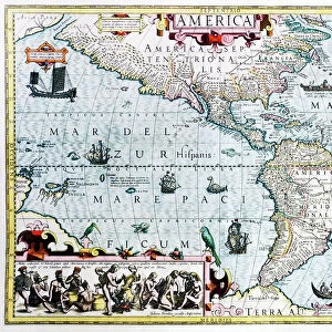
Antique Framed Print : Map Of Southern Brazil, Circa. 1760. From "Atlas De Toutes Les Parties Connues Du Globe Terrestre "By Cartographer Rigobert Bonne. Published Geneva Circa. 1760


![]()
Framed Photos from Design Pics
Map Of Southern Brazil, Circa. 1760. From "Atlas De Toutes Les Parties Connues Du Globe Terrestre "By Cartographer Rigobert Bonne. Published Geneva Circa. 1760
Map Of Southern Brazil, Circa.1760. From " Atlas De Toutes Les Parties Connues Du Globe Terrestre " By Cartographer Rigobert Bonne. Published Geneva Circa. 1760
Design Pics offers Distinctively Different Imagery representing over 1,500 contributors
Media ID 18186427
© Ken Welsh / Design Pics
Brazil Cartography Geography Mapmaking Plate Southern
21"x16" (54x41cm) Antique Frame
Bevelled wood effect frame, card mounted, 15x10 archival quality photo print. Overall outside dimensions 21x16 inches (54x41cm). Environmentally and ozone friendly, Polycore® moulding has the look of real wood, is durable and light and easy to hang. Biodegradable and made with non-chlorinated gases (no toxic fumes) it is efficient; producing 100 tons of polystyrene can save 300 tons of trees! Prints are glazed with lightweight, shatterproof, optical clarity acrylic (providing the same general protection from the environment as glass). The back is stapled hardboard with a sawtooth hanger attached. Note: To minimise original artwork cropping, for optimum layout, and to ensure print is secure, the visible print may be marginally smaller
Bevelled Wood Effect Framed and Mounted Prints - Professionally Made and Ready to Hang
Estimated Image Size (if not cropped) is 37.1cm x 25.4cm (14.6" x 10")
Estimated Product Size is 54cm x 41.4cm (21.3" x 16.3")
These are individually made so all sizes are approximate
Artwork printed orientated as per the preview above, with landscape (horizontal) orientation to match the source image.
FEATURES IN THESE COLLECTIONS
> Maps and Charts
> Related Images
> South America
> Brazil
> Maps
> South America
> Brazil
> Related Images
EDITORS COMMENTS
This print showcases a historical gem - the Map of Southern Brazil, circa 1760. Taken from the renowned "Atlas De Toutes Les Parties Connues Du Globe Terrestre" by esteemed cartographer Rigobert Bonne and published in Geneva around the same time, this map is a true testament to the artistry and precision of early mapmaking. With its vibrant colors and intricate engravings, this horizontal illustration transports us back to a time when exploration and discovery were at their peak. The attention to detail is remarkable, as every contour of the landmasses and water bodies are meticulously depicted. As we delve into this piece of geography's past, we can't help but marvel at how much has changed since then. This snapshot allows us to appreciate the evolution of our understanding of Southern Brazil's landscape over centuries. The plate used for printing adds an extra layer of authenticity to this stunning artwork. Its aged appearance only enhances its charm, reminding us that it has stood the test of time. Ken Welsh's skillful capture ensures that every nuance is preserved in this photo print. Whether you're a history enthusiast or simply appreciate beautiful craftsmanship, this image will undoubtedly captivate your imagination.
MADE IN THE UK
Safe Shipping with 30 Day Money Back Guarantee
FREE PERSONALISATION*
We are proud to offer a range of customisation features including Personalised Captions, Color Filters and Picture Zoom Tools
SECURE PAYMENTS
We happily accept a wide range of payment options so you can pay for the things you need in the way that is most convenient for you
* Options may vary by product and licensing agreement. Zoomed Pictures can be adjusted in the Basket.