Acrylic Blox > Asia > Japan > Maps
Acrylic Blox : Map of the Russo-Japanese War, 1904


![]()
Mounted Prints from Heritage Images
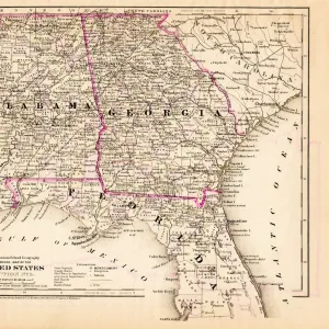
Map of the Russo-Japanese War, 1904
Map of the Russo-Japanese War, 1904. The Russo-Japanese War arose due to the two countries conflicting territorial ambitions in East Asia. When the Russians reneged on an agreement to withdraw troops from Manchuria, the Japanese embarked on a lengthy siege of the Russian-leased city of Port Arthur in Manchuria. Port Arthur surrendered in January 1905, and a combination of incompetence on the part of Russian commanders and the decisive victory for the Japanese navy at the Battle of Tsushima forced the Russians to the negotiating table. The outcome of the war was Japan gaining effective control of Korea and much of Manchuria. An illustration from Le Petit Journal, 15th May 1904
Heritage Images features heritage image collections
Media ID 14881730
© Artmedia / Heritage-Images
Cartography Korea Manchuria Map Making Print Collector5 Russo Japanese War
6"x4" (15x10cm) Acrylic Blox
Your photographic print is held in place by magnets and a micro thin sheet of metal covering the back of a 20mm piece of clear acrylic. Your print is held in place with magnets so can easily be replaced if needed.
Streamlined, one sided modern and attractive table top print
Estimated Product Size is 10.2cm x 15.2cm (4" x 6")
These are individually made so all sizes are approximate
Artwork printed orientated as per the preview above, with portrait (vertical) orientation to match the source image.
FEATURES IN THESE COLLECTIONS
> Asia
> Japan
> Related Images
> Asia
> Related Images
> Europe
> Russia
> Related Images
> Historic
> Battles
> Related Images
> Maps and Charts
> Related Images
> Services
> Royal Navy
EDITORS COMMENTS
This print showcases a detailed "Map of the Russo-Japanese War, 1904". The map serves as a visual representation of the intense conflict that arose between Russia and Japan due to their conflicting territorial ambitions in East Asia. It highlights the key locations and regions involved in this historic war. The Russo-Japanese War was ignited when Russia failed to honor an agreement to withdraw troops from Manchuria. In response, Japan launched a relentless siege on Port Arthur, a Russian-leased city in Manchuria. After months of fierce fighting, Port Arthur finally surrendered in January 1905. The outcome of this war was heavily influenced by both military incompetence on the part of Russian commanders and the decisive victory achieved by the Japanese navy at the Battle of Tsushima. As a result, Japan emerged triumphant and gained effective control over Korea and significant portions of Manchuria. This remarkable illustration from Le Petit Journal dated May 15th, 1904 provides valuable insights into one of history's most significant conflicts. The vibrant colors used in this map bring life to its intricate details while capturing the essence of early 20th-century cartography. Preserved by AccuSoft Inc. , this print stands as a testament to human ambition, power struggles between nations, and how geography played an essential role during times of war.
MADE IN THE UK
Safe Shipping with 30 Day Money Back Guarantee
FREE PERSONALISATION*
We are proud to offer a range of customisation features including Personalised Captions, Color Filters and Picture Zoom Tools
SECURE PAYMENTS
We happily accept a wide range of payment options so you can pay for the things you need in the way that is most convenient for you
* Options may vary by product and licensing agreement. Zoomed Pictures can be adjusted in the Basket.