Acrylic Blox > Europe > France > Paris > Maps
Acrylic Blox : Map of the Country Between Egypt and the Soudan, c1881-85


![]()
Mounted Prints from Heritage Images
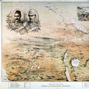
Map of the Country Between Egypt and the Soudan, c1881-85
Map of the Country Between Egypt and the Soudan, c1881-85. Episode of the Mahdist War, (1881-1899). From British Battles on Land and Sea, Vol. IV, by James Grant. [Cassell Petter & Galpin, London, Paris & Melbourne, c1880]
Heritage Images features heritage image collections
Media ID 14992013
© The Print Collector
British Battles On Land And Sea Cassell Petter Galpin Diagram Grant Imperialism James Grant Mahdist War Petter Galpin Sudan Sudan Campaign Cassell Mizraim
8"x6" (20x15cm) Acrylic Blox
Your photographic print is held in place by magnets and a micro thin sheet of metal covering the back of a 20mm piece of clear acrylic. Your print is held in place with magnets so can easily be replaced if needed.
Streamlined, one sided modern and attractive table top print
Estimated Product Size is 20.3cm x 15.2cm (8" x 6")
These are individually made so all sizes are approximate
Artwork printed orientated as per the preview above, with landscape (horizontal) orientation to match the source image.
FEATURES IN THESE COLLECTIONS
> Africa
> Sudan
> Related Images
> Arts
> Literature
> Europe
> France
> Canton
> Landes
> Europe
> France
> Paris
> Maps
> Historic
> Battles
> Related Images
> Maps and Charts
> Related Images
EDITORS COMMENTS
This print showcases a historical map titled "Map of the Country Between Egypt and the Soudan, c1881-85". Taken from James Grant's book "British Battles on Land and Sea" this image takes us back to the late 19th century, during the intense period known as the Mahdist War (1881-1899). The map itself is a remarkable piece of cartography, illustrating the region between Egypt and Sudan. It provides valuable insight into the geographical layout of these countries during that time, shedding light on their colonial history. The intricate details depicted in monochrome highlight various locations, including Mizraim. As we delve deeper into this photograph, it becomes evident that it represents more than just a mere map. It symbolizes Britain's imperialistic ambitions during this era of colonialism. The British battles fought on land and sea are brought to life through Grant's work, reminding us of significant historical events such as the Sudan Campaign. Preserved by The Print Collector29 under its collection dedicated to colonialism and imperialism, this print serves as a visual testament to an era marked by power struggles between nations. Its inclusion in Heritage Images allows us to appreciate not only its artistic value but also its historical significance.
MADE IN THE UK
Safe Shipping with 30 Day Money Back Guarantee
FREE PERSONALISATION*
We are proud to offer a range of customisation features including Personalised Captions, Color Filters and Picture Zoom Tools
SECURE PAYMENTS
We happily accept a wide range of payment options so you can pay for the things you need in the way that is most convenient for you
* Options may vary by product and licensing agreement. Zoomed Pictures can be adjusted in the Basket.