Acrylic Blox > North America > United States of America > Indiana > Indianapolis
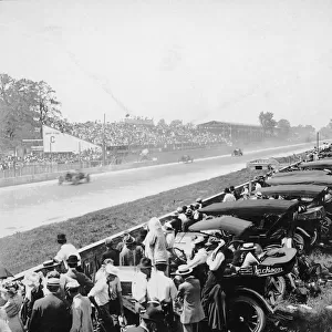
Acrylic Blox : Wind chart map 1889


![]()
Mounted Prints from Fine Art Storehouse
Wind chart map 1889
Indiana Educational Series The Complete Geography - Indianapolis 1889
Unleash your creativity and transform your space into a visual masterpiece!
THEPALMER
Media ID 14756314
© This content is subject to copyright
6"x4" (15x10cm) Acrylic Blox
Your photographic print is held in place by magnets and a micro thin sheet of metal covering the back of a 20mm piece of clear acrylic. Your print is held in place with magnets so can easily be replaced if needed.
Streamlined, one sided modern and attractive table top print
Estimated Product Size is 15.2cm x 10.2cm (6" x 4")
These are individually made so all sizes are approximate
Artwork printed orientated as per the preview above, with landscape (horizontal) orientation to match the source image.
FEATURES IN THESE COLLECTIONS
> Animals
> Mammals
> Muridae
> Western Mouse
> Maps and Charts
> Related Images
> North America
> United States of America
> Indiana
> Indianapolis
> Fine Art Storehouse
> Map
> Historical Maps
EDITORS COMMENTS
This print titled "Wind chart map 1889" takes us back to the late 19th century, specifically Indianapolis in 1889. Part of the Indiana Educational Series The Complete Geography, this intricate wind chart map provides a fascinating glimpse into how knowledge was disseminated during that era. The image showcases both the eastern and western regions, offering a comprehensive view of the prevailing wind patterns at that time. With meticulous attention to detail, THEPALMER has beautifully captured every nuance of this historical artifact, making it an ideal addition for any art enthusiast or history buff. As we delve into this piece, we are transported to a bygone era when cartography played a crucial role in understanding our world. The delicate lines and carefully drawn arrows on the map depict not only geographical boundaries but also serve as visual representations of nature's forces. Beyond its aesthetic appeal, this photograph print serves as a reminder of humanity's constant quest for knowledge and exploration. It invites us to reflect on how far we have come since then while appreciating the efforts made by those who came before us in unraveling Earth's mysteries. Whether displayed in a classroom setting or adorning your living space, this remarkable artwork is sure to spark curiosity and ignite conversations about our planet's ever-changing dynamics.
MADE IN THE UK
Safe Shipping with 30 Day Money Back Guarantee
FREE PERSONALISATION*
We are proud to offer a range of customisation features including Personalised Captions, Color Filters and Picture Zoom Tools
SECURE PAYMENTS
We happily accept a wide range of payment options so you can pay for the things you need in the way that is most convenient for you
* Options may vary by product and licensing agreement. Zoomed Pictures can be adjusted in the Basket.