Home > Arts > Artists > H > Franz Hogenberg
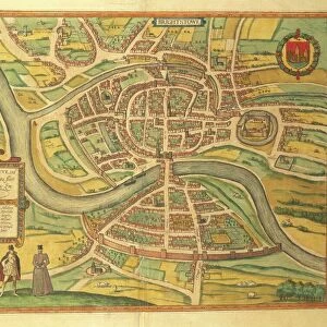
Map of Orleans and Bourges from Civitates Orbis Terrarum by Georg Braun, 1541-1622 and Franz Hogenberg, 1540-1590, engraving

![]()
Wall Art and Photo Gifts from Universal Images Group (UIG)
Map of Orleans and Bourges from Civitates Orbis Terrarum by Georg Braun, 1541-1622 and Franz Hogenberg, 1540-1590, engraving
Cartography, France, 16th century. Map of Orleans and Bourges. From Civitates Orbis Terrarum by Georg Braun (1541-1622) and Franz Hogenberg (1540-1590), Cologne. Engraving
Universal Images Group (UIG) manages distribution for many leading specialist agencies worldwide
Media ID 9504375
© DEA / R. MERLO
16th Century Castle Manuscript Orleans Pasture River Townscape Animal Representation Bourges
FEATURES IN THESE COLLECTIONS
> Arts
> Artists
> H
> Franz Hogenberg
> Arts
> Landscape paintings
> Waterfall and river artworks
> River artworks
> Universal Images Group (UIG)
> Art
> Painting, Sculpture & Prints
> Cartography
EDITORS COMMENTS
This print showcases a historical gem - the Map of Orleans and Bourges from Civitates Orbis Terrarum by Georg Braun and Franz Hogenberg. Created in the 16th century, this engraving takes us back to an era when cartography was both an art form and a scientific endeavor. The intricate details of this map are truly remarkable. It offers a glimpse into the physical geography of France during that time, with its townscape, river, and even representations of animals. The absence of human figures allows us to focus solely on the landscape itself, emphasizing its natural beauty. The studio shot captures every nuance of this masterpiece, highlighting its delicate lines and expert craftsmanship. It is evident that great care was taken in creating this work, as each stroke contributes to the overall composition. As we explore this map further, we can't help but imagine what life was like in Orleans and Bourges centuries ago. The presence of a castle hints at their rich history while also adding an air of mystery to these ancient towns. In essence, this print not only serves as a visual delight but also acts as a portal through which we can travel back in time. It reminds us of the importance placed on cartography throughout history and invites us to appreciate it as both an art form and a valuable tool for understanding our world.
MADE IN THE UK
Safe Shipping with 30 Day Money Back Guarantee
FREE PERSONALISATION*
We are proud to offer a range of customisation features including Personalised Captions, Color Filters and Picture Zoom Tools
SECURE PAYMENTS
We happily accept a wide range of payment options so you can pay for the things you need in the way that is most convenient for you
* Options may vary by product and licensing agreement. Zoomed Pictures can be adjusted in the Basket.