Home > Arts > Artists > C > Calopodio da Candia
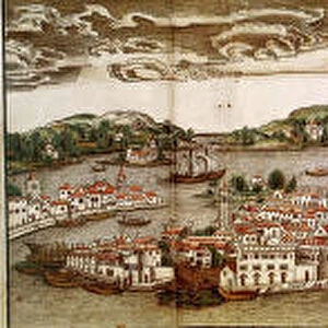
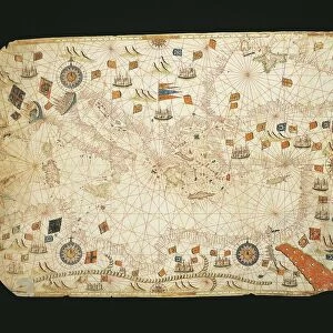
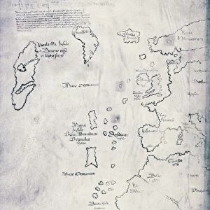
Map of Iceland, from Nautical Atlas by Giorgio Sideri called Callapoda or Calopodio da Candia, Crete, 1537

![]()
Wall Art and Photo Gifts from Universal Images Group (UIG)
Map of Iceland, from Nautical Atlas by Giorgio Sideri called Callapoda or Calopodio da Candia, Crete, 1537
Cartography, 16th century. Map of Iceland, from a Nautical Atlas by Giorgio Sideri called Callapoda or Calopodio da Candia (Crete), 1537
Universal Images Group (UIG) manages distribution for many leading specialist agencies worldwide
Media ID 9501173
© DEA / A. DAGLI ORTI
16th Century Close Up Coastline Fire Fish Flame Iceland Medium Group Of Animals Mountain Western Script
FEATURES IN THESE COLLECTIONS
> Animals
> Fishes
> Related Images
> Arts
> Artists
> C
> Calopodio da Candia
> Europe
> Iceland
> Paintings
> Europe
> Iceland
> Sculptures
> Universal Images Group (UIG)
> Art
> Painting, Sculpture & Prints
> Cartography
EDITORS COMMENTS
This print showcases a remarkable piece of cartographic history - the Map of Iceland from the Nautical Atlas by Giorgio Sideri, also known as Callapoda or Calopodio da Candia. Created in 1537 on the beautiful island of Crete, this 16th-century map is a testament to human curiosity and exploration. Intriguing details come to life as we zoom in on this close-up shot. The rugged Icelandic mountains dominate the landscape, their majestic peaks reaching towards the heavens. A tranquil sea surrounds the island, its waves gently lapping against the coastline. A quaint hut stands proudly amidst nature's grandeur, offering shelter to those who dare venture into these untamed lands. The artist's skillful brushstrokes bring forth an array of elements that define Iceland's physical geography. From fish swimming gracefully in pristine waters to trees swaying with ethereal grace, every detail contributes to an immersive experience. A flame flickers near the hut, casting a warm glow upon this historical masterpiece. It serves as a reminder of both man's desire for warmth and his ability to harness fire for survival. As we admire this vertical composition bathed in daylight, it transports us back in time - connecting us with generations past who sought knowledge through maps like these. Western script adorns its surface, guiding explorers through uncharted territories and igniting their imaginations. This artful creation evokes a sense of wonder and invites us to explore not only Iceland
MADE IN THE UK
Safe Shipping with 30 Day Money Back Guarantee
FREE PERSONALISATION*
We are proud to offer a range of customisation features including Personalised Captions, Color Filters and Picture Zoom Tools
SECURE PAYMENTS
We happily accept a wide range of payment options so you can pay for the things you need in the way that is most convenient for you
* Options may vary by product and licensing agreement. Zoomed Pictures can be adjusted in the Basket.