Home > Animals > Mammals > Muridae > Magnus
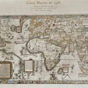
Carta Marina, Sea Map by Olaus Magnus, 1539

![]()
Wall Art and Photo Gifts from Universal Images Group (UIG)
Carta Marina, Sea Map by Olaus Magnus, 1539
Cartography, Iceland, 16th century. Carta Marina (Sea Map) by Olaus Magnus, 1539
Universal Images Group (UIG) manages distribution for many leading specialist agencies worldwide
Media ID 9500685
© DEA / M. SEEMULLER
16th Century Coastline Geography Iceland Island Monster Tall Ship Olaus Magnus Sea Map
FEATURES IN THESE COLLECTIONS
> Animals
> Mammals
> Muridae
> Magnus
> Europe
> Iceland
> Paintings
> Europe
> Iceland
> Sculptures
> Universal Images Group (UIG)
> Art
> Painting, Sculpture & Prints
> Cartography
EDITORS COMMENTS
This print showcases the remarkable "Carta Marina, Sea Map" by Olaus Magnus, dating back to 1539. A true masterpiece of cartography from the 16th century, this map offers a fascinating glimpse into Iceland's geography and topography during that era. The intricate details and precision in depicting the island's coastline are truly awe-inspiring. As one delves deeper into this vertical composition, they will be intrigued by the presence of a monstrous sea creature lurking in the depths of the ocean. This mythical creature adds an element of mystery and adventure to an already mesmerizing artwork. The tall ship depicted on this map further enhances its historical significance, reminding us of the brave explorers who sailed these treacherous waters centuries ago. It serves as a testament to their courage and determination in charting unknown territories. Olaus Magnus' skillful use of illustration and painting techniques is evident throughout this piece. His attention to detail brings every aspect of this sea map to life - from meticulously drawn coastlines to vibrant colors representing different regions. This extraordinary print captures not only a significant moment in history but also invites viewers on an enchanting journey through time. It is a visual treasure that allows us to appreciate both the artistry involved in cartography and our ever-evolving understanding of our planet's vast oceans.
MADE IN THE UK
Safe Shipping with 30 Day Money Back Guarantee
FREE PERSONALISATION*
We are proud to offer a range of customisation features including Personalised Captions, Color Filters and Picture Zoom Tools
SECURE PAYMENTS
We happily accept a wide range of payment options so you can pay for the things you need in the way that is most convenient for you
* Options may vary by product and licensing agreement. Zoomed Pictures can be adjusted in the Basket.