Tote Bag > Animals > Mammals > Cats (Domestic) > Russian White
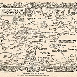
Tote Bag : Map Geography Moscow Russia


![]()
Home Decor from Universal Images Group (UIG)
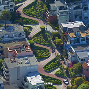
Map Geography Moscow Russia
Map of Moscow, " Atlas Geographicus et Topographicus", 1643. (Photo by: Universal History Archive/UIG)
Universal Images Group (UIG) manages distribution for many leading specialist agencies worldwide
Media ID 20165355
© JT Vintage / Glasshouse Images
1643 Aerial View B And W Moscow B And
Canvas Tote Bag
Our tote bags are made from soft, durable, poly-poplin fabric and include a one inch (2.5cm) black strap for easy carrying on your shoulder. All seams are double-stitched for added durability. Each tote bag is machine-washable in cold water and is printed on both sides using the same image. Approximate size of bag is 50x33cm (20"x13")
Our tote bags are made from soft durable fabric and include a strap for easy carrying
Estimated Product Size is 50cm x 32.7cm (19.7" x 12.9")
These are individually made so all sizes are approximate
FEATURES IN THESE COLLECTIONS
> Aerial Photography
> Related Images
> Animals
> Mammals
> Cats (Domestic)
> Russian White
> Europe
> Russia
> Aerial Views
> Europe
> Russia
> Related Images
> Maps and Charts
> Early Maps
> Maps and Charts
> Related Images
> Universal Images Group (UIG)
> History
> Historical Maps
EDITORS COMMENTS
This print takes us back in time to the year 1643, showcasing a historical illustration of Moscow, Russia. The detailed map, titled "Atlas Geographicus et Topographicus" offers a fascinating glimpse into the geography and topography of this iconic city. With its aerial view perspective, we are able to appreciate the layout and structure of Moscow during that era. The absence of people in this image allows us to focus solely on the intricate details presented by JT Vintage / Glasshouse Images. Every street, building, and landmark is meticulously depicted, giving us an insight into how Moscow appeared centuries ago. This vintage piece transports us through time as we explore the rich history embedded within its lines. The monochromatic color scheme adds a touch of nostalgia to this print, enhancing its retro aesthetic. The horizontal composition further emphasizes the vastness and expansiveness of Moscow's landscape during that period. Whether you're a history enthusiast or simply captivated by old-world charm, this print serves as both an educational tool and a decorative piece for any space. It invites viewers to delve into the past while appreciating the artistry behind cartography. Let your imagination wander as you immerse yourself in this remarkable depiction of one of Europe's most renowned cities – Moscow.
MADE IN THE UK
Safe Shipping with 30 Day Money Back Guarantee
FREE PERSONALISATION*
We are proud to offer a range of customisation features including Personalised Captions, Color Filters and Picture Zoom Tools
SECURE PAYMENTS
We happily accept a wide range of payment options so you can pay for the things you need in the way that is most convenient for you
* Options may vary by product and licensing agreement. Zoomed Pictures can be adjusted in the Basket.