Tote Bag > North America > United States of America > Maps
Tote Bag : USA Railway Map


![]()
Home Decor from Mary Evans Picture Library
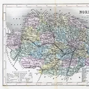
USA Railway Map
Transcontinental railway map of the United States of America and the adjoining British possessions. Date: 1883
Mary Evans Picture Library makes available wonderful images created for people to enjoy over the centuries
Media ID 4320780
© Mary Evans Picture Library 2015 - https://copyrighthub.org/s0/hub1/creation/maryevans/MaryEvansPictureID/10127701
1883 Adjoining Maps Possessions Transcontinental
Canvas Tote Bag
Our tote bags are made from soft, durable, poly-poplin fabric and include a one inch (2.5cm) black strap for easy carrying on your shoulder. All seams are double-stitched for added durability. Each tote bag is machine-washable in cold water and is printed on both sides using the same image. Approximate size of bag is 50x33cm (20"x13")
Our tote bags are made from soft durable fabric and include a strap for easy carrying
Estimated Product Size is 50cm x 32.7cm (19.7" x 12.9")
These are individually made so all sizes are approximate
FEATURES IN THESE COLLECTIONS
> Maps and Charts
> Early Maps
> Maps and Charts
> Related Images
> North America
> United States of America
> Maps
> Popular Themes
> Railway Posters
EDITORS COMMENTS
This print showcases a piece of history that transformed the landscape and connected the vast expanse of the United States in 1883. The USA Railway Map depicts the intricate network of railways that crisscrossed the country, linking major cities and territories from coast to coast. This transcontinental railway map not only highlights the impressive engineering feat of its time but also symbolizes progress, unity, and expansion.
As we study this detailed map, we can trace the routes that played a crucial role in shaping America's growth and development during this pivotal period in history. From bustling urban centers to remote frontier outposts, these railways served as lifelines for transporting goods, people, and ideas across vast distances.
The inclusion of adjoining British possessions on this map serves as a reminder of international cooperation and trade connections that were essential for economic prosperity at the time. It is a testament to how transportation infrastructure has always been key to fostering relationships between nations.
Through this historical lens, we gain insight into how rail transport revolutionized travel and commerce in America while also reflecting on the challenges overcome by early pioneers who laid down tracks through rugged terrain and untamed wilderness. This remarkable visual artifact invites us to explore our past with curiosity and appreciation for those who paved the way for modern transportation systems.
MADE IN THE UK
Safe Shipping with 30 Day Money Back Guarantee
FREE PERSONALISATION*
We are proud to offer a range of customisation features including Personalised Captions, Color Filters and Picture Zoom Tools
SECURE PAYMENTS
We happily accept a wide range of payment options so you can pay for the things you need in the way that is most convenient for you
* Options may vary by product and licensing agreement. Zoomed Pictures can be adjusted in the Basket.