Tote Bag > Europe > United Kingdom > Scotland > Edinburgh > Edinburgh
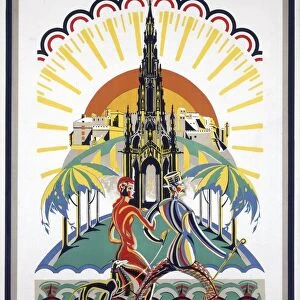
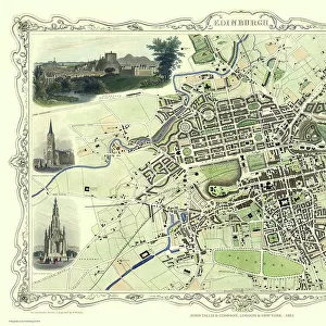
Tote Bag : Pictorial map of Edinburgh


![]()
Home Decor from Mary Evans Picture Library
Pictorial map of Edinburgh
Pictorial map of Edinburgh Date: circa 1950s
Mary Evans Picture Library makes available wonderful images created for people to enjoy over the centuries
Media ID 8201675
© Mary Evans Picture Library 2015 - https://copyrighthub.org/s0/hub1/creation/maryevans/MaryEvansPictureID/10645858
Canvas Tote Bag
Our tote bags are made from soft, durable, poly-poplin fabric and include a one inch (2.5cm) black strap for easy carrying on your shoulder. All seams are double-stitched for added durability. Each tote bag is machine-washable in cold water and is printed on both sides using the same image. Approximate size of bag is 50x33cm (20"x13")
Our tote bags are made from soft durable fabric and include a strap for easy carrying
Estimated Product Size is 32.7cm x 50cm (12.9" x 19.7")
These are individually made so all sizes are approximate
FEATURES IN THESE COLLECTIONS
> Europe
> France
> Canton
> Landes
> Europe
> United Kingdom
> Scotland
> Edinburgh
> Edinburgh
> Europe
> United Kingdom
> Scotland
> Edinburgh
> Europe
> United Kingdom
> Scotland
> Lothian
> Edinburgh
> Europe
> United Kingdom
> Scotland
> Maps
> Europe
> United Kingdom
> Scotland
> Posters
> Europe
> United Kingdom
> Scotland
> Related Images
> Maps and Charts
> Related Images
EDITORS COMMENTS
1. Title: "A Journey Through Time: Edinburgh in the 1950s as Depicted in this Vintage Pictorial Map This pictorial map of Edinburgh, Scotland, transports us back in time to the 1950s. The intricate details and charming illustrations offer a unique perspective of the city during an era of significant change. Edinburgh, the historic capital city of Scotland, is depicted in all its glory. The map highlights iconic landmarks, such as Edinburgh Castle, Arthur's Seat, and Calton Hill, which have stood the test of time and continue to be major tourist attractions. The map also showcases the city's vibrant neighborhoods, including Leith, New Town, and Old Town, each with its distinct character. The 1950s were a period of post-war recovery and optimism in Scotland. This map reflects the city's progress during this time, with new developments such as the Forth Road Bridge and the Royal Festival Hall making their appearance. The map also reveals the city's rich cultural heritage, with traditional Scottish activities like bagpipe playing and Highland dancing depicted alongside modern urban life. The pictorial map's intricate design and attention to detail offer a fascinating glimpse into Edinburgh's past. The use of warm colors and whimsical illustrations adds to the nostalgic charm, making this map a must-have for anyone with a connection to Scotland or an interest in the history of Edinburgh. As we explore this vintage map, we can't help but be captivated by the story it tells of a city and a time long gone. It serves as a reminder of the past while also highlighting the enduring charm and beauty of Edinburgh, making it a cherished piece of Scottish history.
MADE IN THE UK
Safe Shipping with 30 Day Money Back Guarantee
FREE PERSONALISATION*
We are proud to offer a range of customisation features including Personalised Captions, Color Filters and Picture Zoom Tools
SECURE PAYMENTS
We happily accept a wide range of payment options so you can pay for the things you need in the way that is most convenient for you
* Options may vary by product and licensing agreement. Zoomed Pictures can be adjusted in the Basket.