Tote Bag > Arts > Photorealistic artworks > Meticulous attention to detail > Detailed artwork
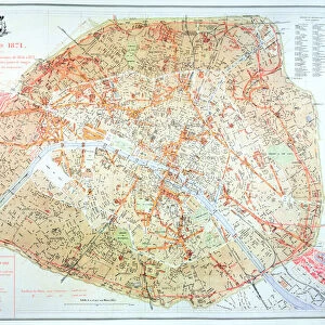
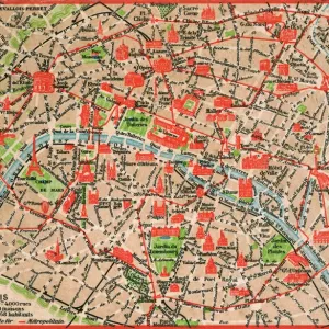
Tote Bag : Paris at the Outbreak of the French Revolution 1789


![]()
Home Decor from MapSeeker
Paris at the Outbreak of the French Revolution 1789
This is a detailed Plan of Paris showing the Parks, Gardens and Squares, Palaces, Bridges over the River Seine, Churches, Convents, Prisons and all the historic Buildings of Importance at the time of the outbreak of the French Revolution 1789. It has been meticulously recreated from the rare antique original by Mapseeker
Welcome to the Mapseeker Image library and enter an historic gateway to one of the largest on-line collections of Historic Maps, Nostalgic Views, Vista's and Panorama's from a World gone by.
Media ID 20347078
© Mapseeker Publishing Ltd
Europe City Europe City Plan European City Map European City Plan Historic Map Old Town Plan French City French Revolution Paris City
Canvas Tote Bag
Our tote bags are made from soft, durable, poly-poplin fabric and include a one inch (2.5cm) black strap for easy carrying on your shoulder. All seams are double-stitched for added durability. Each tote bag is machine-washable in cold water and is printed on both sides using the same image. Approximate size of bag is 50x33cm (20"x13")
Our tote bags are made from soft durable fabric and include a strap for easy carrying
Estimated Product Size is 50cm x 32.7cm (19.7" x 12.9")
These are individually made so all sizes are approximate
FEATURES IN THESE COLLECTIONS
> MapSeeker
> British History Related and Military
> 16th to 19th Century PORTFOLIO
> MapSeeker
> Maps of Europe
> Maps of France PORTFOLIO
> Animals
> Insects
> Spiders
> European Garden
> Arts
> Photorealistic artworks
> Detailed art pieces
> Masterful detailing in art
> Arts
> Photorealistic artworks
> Meticulous attention to detail
> Detailed artwork
> Arts
> Photorealistic artworks
> Meticulous attention to detail
> Fine art
> Europe
> France
> Paris
> Maps
> Europe
> France
> Paris
> River Seine
> Maps and Charts
> Related Images
> Religious Art
> Religious Architecture
> Churches and Cathedrals
EDITORS COMMENTS
This print takes us back to the tumultuous time of the French Revolution in 1789, offering a detailed plan of Paris as it stood during this historic period. Meticulously recreated from a rare antique original by Mapseeker, this map provides an invaluable glimpse into the city's landscape at the outbreak of one of history's most significant events. The image showcases not only the iconic landmarks and architectural marvels that define Paris but also delves deeper into its fabric, revealing parks, gardens, squares, palaces, bridges over the River Seine, churches, convents, prisons and other buildings of great importance during that era. Every element has been painstakingly preserved to transport viewers back in time and immerse them in the atmosphere of revolutionary France. George Bradshaw's expertise shines through this exceptional work published by Mapseeker Publishing Ltd. The attention to detail is evident as every street corner and alleyway is meticulously depicted on this old town plan. This map serves as both a historical artifact and a testament to human resilience amidst political upheaval. Whether you are an avid historian or simply fascinated by maps and their ability to tell stories about our past, this print offers a unique opportunity to explore Paris at a pivotal moment in its history. Step into the shoes of those who witnessed firsthand the birth pangs of revolution with this remarkable piece from MapSeeker.
MADE IN THE UK
Safe Shipping with 30 Day Money Back Guarantee
FREE PERSONALISATION*
We are proud to offer a range of customisation features including Personalised Captions, Color Filters and Picture Zoom Tools
SECURE PAYMENTS
We happily accept a wide range of payment options so you can pay for the things you need in the way that is most convenient for you
* Options may vary by product and licensing agreement. Zoomed Pictures can be adjusted in the Basket.