Tote Bag > Europe > Republic of Ireland > Maps
Tote Bag : British Isles Counties, Districts and Unitary Authorities Map


![]()
Home Decor from Map Marketing
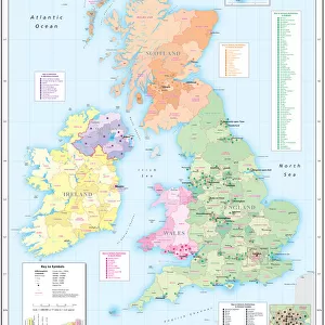
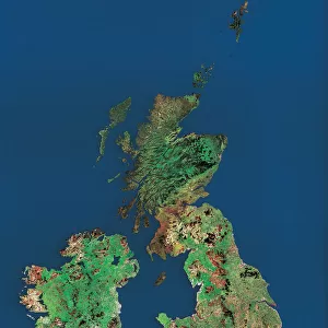
British Isles Counties, Districts and Unitary Authorities Map
A political map of the UK and Ireland showing all County, District and Unitary Authority boundaries. Each County is clearly divided into its local District Council areas and each administrative area is shown in a different colour to its neighbours. The map base shows towns, cities motorways and primary roads. Includes a small Postcode Area inset map and a London Borough map. Ireland shown as an inset with all County boundaries for the Republic. Population figures are displayed by administrative division
Media ID 19949237
© Map Marketing Ltd
Canvas Tote Bag
Our tote bags are made from soft, durable, poly-poplin fabric and include a one inch (2.5cm) black strap for easy carrying on your shoulder. All seams are double-stitched for added durability. Each tote bag is machine-washable in cold water and is printed on both sides using the same image. Approximate size of bag is 50x33cm (20"x13")
Our tote bags are made from soft durable fabric and include a strap for easy carrying
Estimated Product Size is 32.7cm x 50cm (12.9" x 19.7")
These are individually made so all sizes are approximate
FEATURES IN THESE COLLECTIONS
> Map Marketing
> UK Maps
> Europe
> Republic of Ireland
> Maps
> Europe
> Republic of Ireland
> Related Images
> Europe
> United Kingdom
> England
> London
> Boroughs
> Related Images
> Europe
> United Kingdom
> England
> London
> Politics
> Related Images
> Europe
> United Kingdom
> Maps
> Maps and Charts
> Popular Maps
> Maps and Charts
> Related Images
MADE IN THE UK
Safe Shipping with 30 Day Money Back Guarantee
FREE PERSONALISATION*
We are proud to offer a range of customisation features including Personalised Captions, Color Filters and Picture Zoom Tools
SECURE PAYMENTS
We happily accept a wide range of payment options so you can pay for the things you need in the way that is most convenient for you
* Options may vary by product and licensing agreement. Zoomed Pictures can be adjusted in the Basket.