Tote Bag > Granger Art on Demand > U.S. Cities
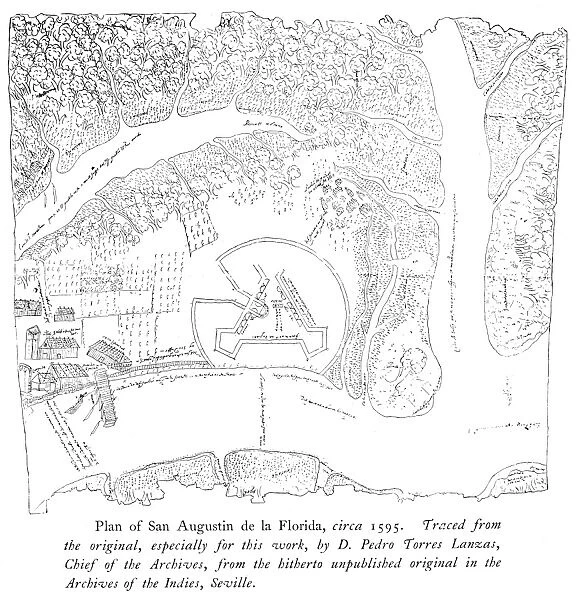
Tote Bag : ST. AUGUSTINE: MAP. 19th century tracing of the Mestas map of St. Augustine, Florida
![]()

Home Decor from Granger
ST. AUGUSTINE: MAP. 19th century tracing of the Mestas map of St. Augustine, Florida
ST. AUGUSTINE: MAP.
19th century tracing of the Mestas map of St. Augustine, Florida, carried to Spain in 1594-95 by Hernando de Mestas. It is believed to have been drawn as much as thirty years earlier
Granger holds millions of images spanning more than 25,000 years of world history, from before the Stone Age to the dawn of the Space Age
Media ID 12570657
Augustine Colony Florida Fort Hernando New World Saint Settlement Spanish Topography United States Southeast Tracing
Canvas Tote Bag
Our tote bags are made from soft, durable, poly-poplin fabric and include a one inch (2.5cm) black strap for easy carrying on your shoulder. All seams are double-stitched for added durability. Each tote bag is machine-washable in cold water and is printed on both sides using the same image. Approximate size of bag is 50x33cm (20"x13")
Our tote bags are made from soft durable fabric and include a strap for easy carrying
Estimated Product Size is 32.7cm x 50cm (12.9" x 19.7")
These are individually made so all sizes are approximate
EDITORS COMMENTS
This print showcases a 19th-century tracing of the Mestas map of St. Augustine, Florida. This historic artifact was carried to Spain in 1594-95 by the intrepid explorer Hernando de Mestas and is believed to have been drawn as early as thirty years prior. The intricate details depicted on this map provide us with a glimpse into the vibrant past of this remarkable city. St. Augustine, known for its rich history and cultural significance, stands tall as one of America's oldest settlements. This meticulously crafted map offers an invaluable insight into the topography and layout of this colonial gem during its formative years in the New World. As we delve into this visual masterpiece, we are transported back to a time when Spanish influence permeated every corner of St. Augustine's streets and riverbanks. The fort that once guarded these lands proudly takes center stage, reminding us of the strategic importance placed upon defending this precious colony. With each stroke on paper, centuries-old secrets unfold before our eyes – secrets that shaped not only St. Augustine but also laid down foundations for future generations in Southeast America. It serves as a testament to the Renaissance spirit that propelled explorers like Hernando de Mestas across uncharted territories. This print from Granger Art on Demand encapsulates both artistry and historical significance within its frame, inviting viewers to embark on a journey through time while marveling at the wonders held within St. Augustine's storied past.
MADE IN THE UK
Safe Shipping with 30 Day Money Back Guarantee
FREE PERSONALISATION*
We are proud to offer a range of customisation features including Personalised Captions, Color Filters and Picture Zoom Tools
SECURE PAYMENTS
We happily accept a wide range of payment options so you can pay for the things you need in the way that is most convenient for you
* Options may vary by product and licensing agreement. Zoomed Pictures can be adjusted in the Basket.


