Tote Bag > Arts > Artists > W > Wilson Wilson
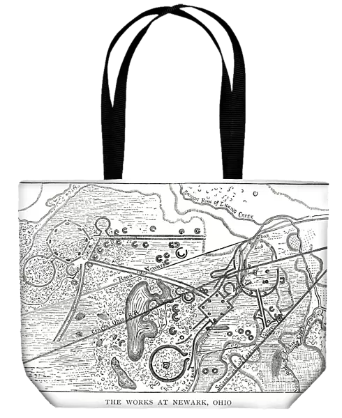
Tote Bag : woodcut map illustration of Newark Earthworks, Ohio
![]()

Home Decor from Fine Art Storehouse
woodcut map illustration of Newark Earthworks, Ohio
Woodcut map of Newark Earthworks, Ohio, USA. Built during Hopewell culture. 1889 facsimile of 1862 map in Prehistoric Man by Daniel Wilson
Unleash your creativity and transform your space into a visual masterpiece!
NNehring
Media ID 18356587
Canvas Tote Bag
Our tote bags are made from soft, durable, poly-poplin fabric and include a one inch (2.5cm) black strap for easy carrying on your shoulder. All seams are double-stitched for added durability. Each tote bag is machine-washable in cold water and is printed on both sides using the same image. Approximate size of bag is 50x33cm (20"x13")
Our tote bags are made from soft durable fabric and include a strap for easy carrying
Estimated Product Size is 50cm x 32.7cm (19.7" x 12.9")
These are individually made so all sizes are approximate
FEATURES IN THESE COLLECTIONS
> Fine Art Storehouse
> Map
> Historical Maps
> Fine Art Storehouse
> Map
> USA Maps
> Arts
> Artists
> W
> Wilson Wilson
> Maps and Charts
> Related Images
> North America
> United States of America
> Maps
> North America
> United States of America
> Ohio
> Related Images
EDITORS COMMENTS
This print showcases a remarkable woodcut map illustration of the Newark Earthworks in Ohio, USA. The intricate details and exquisite craftsmanship of this 1889 facsimile, based on a map from 1862 found in Daniel Wilson's Prehistoric Man, transport us back to the era of the Hopewell culture. The Newark Earthworks are an awe-inspiring testament to human ingenuity and architectural prowess. Created by the Hopewell people centuries ago, these earthworks hold immense cultural significance and continue to captivate historians and archaeologists today. The woodcut map beautifully captures the complexity and grandeur of these ancient structures. From above, we can see how interconnected mounds, geometric shapes, embankments, and pathways form an elaborate network within the landscape. Each element meticulously crafted with precision. As we gaze upon this print, our imagination takes flight as we envision what life might have been like for those who built these impressive earthworks. We ponder their purpose - were they ceremonial sites? Astronomical observatories? Or perhaps both? NNehring's skillful photography allows us to appreciate every line etched into this historic representation. It serves as a reminder that art has the power not only to preserve history but also to ignite curiosity about our past. Whether you're an enthusiast of archaeology or simply drawn to stunning works of art that tell stories from long ago, this woodcut map print is sure to be a cherished addition to any collection or display space.
MADE IN THE UK
Safe Shipping with 30 Day Money Back Guarantee
FREE PERSONALISATION*
We are proud to offer a range of customisation features including Personalised Captions, Color Filters and Picture Zoom Tools
SECURE PAYMENTS
We happily accept a wide range of payment options so you can pay for the things you need in the way that is most convenient for you
* Options may vary by product and licensing agreement. Zoomed Pictures can be adjusted in the Basket.


