Tote Bag > Europe > United Kingdom > England > Suffolk > Ipswich
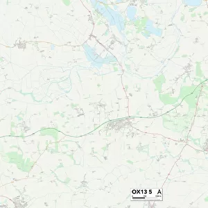
Tote Bag : Ipswich Suffolk UK City Street Map


![]()
Home Decor from Fine Art Storehouse
Ipswich Suffolk UK City Street Map
Vector Illustration of a City Street Map of Ipswich, Suffolk, UK. Included files are EPS (v10) and Hi-Res JPG.
Data courtesy from Ordnance Survey: VectorMap District
https:/ordnancesurvey.co.uk/business-and-government/products/vectormap-district.html
OS OpenData is free to use under the Open Government Licence (OGL).
Contains OS data eCrown copyright and database right 2017.
http:/nationalarchives.gov.uk/doc/open-government-licence/version/3/
Unleash your creativity and transform your space into a visual masterpiece!
Frank Ramspott
Media ID 15055261
© Frank Ramspott, all rights reserved
Aerial View Computer Graphic Directly Above Gray Green Road Map Street Map Suffolk Text Digitally Generated Image Ipswich River Orwell
Canvas Tote Bag
Our tote bags are made from soft, durable, poly-poplin fabric and include a one inch (2.5cm) black strap for easy carrying on your shoulder. All seams are double-stitched for added durability. Each tote bag is machine-washable in cold water and is printed on both sides using the same image. Approximate size of bag is 50x33cm (20"x13")
Our tote bags are made from soft durable fabric and include a strap for easy carrying
Estimated Product Size is 32.7cm x 50cm (12.9" x 19.7")
These are individually made so all sizes are approximate
FEATURES IN THESE COLLECTIONS
> Fine Art Storehouse
> Map
> Street Maps
> Aerial Photography
> Related Images
> Arts
> Contemporary art
> Digital artwork
> Street art
> Arts
> Landscape paintings
> Waterfall and river artworks
> River artworks
> Arts
> Portraits
> Pop art gallery
> Street art portraits
> Arts
> Street art graffiti
> Digital art
> Digital paintings
> Arts
> Street art graffiti
> Digital art
> Vector illustrations
> Europe
> United Kingdom
> England
> Suffolk
> Ipswich
> Europe
> United Kingdom
> England
> Suffolk
> Related Images
> Europe
> United Kingdom
> Maps
> Maps and Charts
> Related Images
EDITORS COMMENTS
This print showcases a meticulously detailed vector illustration of Ipswich, Suffolk, UK. The city street map is expertly crafted, highlighting the intricate road network and architectural landmarks that define this charming town. With files available in EPS (v10) and Hi-Res JPG formats, this artwork offers versatility for various creative projects. The data used to create this stunning piece of cartography is courtesy of Ordnance Survey's VectorMap District. This reliable source ensures accuracy and authenticity in capturing the essence of Ipswich's streetscape. Moreover, it is important to note that OS OpenData allows free usage under the Open Government Licence (OGL), emphasizing accessibility and promoting open information sharing. The image encompasses an aerial view directly above Ipswich, providing a unique perspective on its physical geography. The color palette consists of shades of gray, green, blue, and white which beautifully complement each other while adding depth to the composition. Designed digitally by Frank Ramspott with great attention to detail, this visually striking artwork does not feature any people but rather focuses solely on showcasing the city's layout and infrastructure. It serves as both a functional tool for navigation purposes and as an aesthetically pleasing piece that captures the essence of Ipswich's urban landscape.
MADE IN THE UK
Safe Shipping with 30 Day Money Back Guarantee
FREE PERSONALISATION*
We are proud to offer a range of customisation features including Personalised Captions, Color Filters and Picture Zoom Tools
SECURE PAYMENTS
We happily accept a wide range of payment options so you can pay for the things you need in the way that is most convenient for you
* Options may vary by product and licensing agreement. Zoomed Pictures can be adjusted in the Basket.