Tote Bag > North America > United States of America > New York > New York > Maps
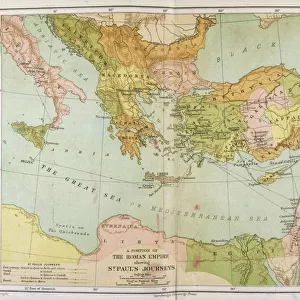
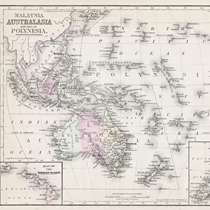
Tote Bag : Map of the roman empire 1883


![]()
Home Decor from Fine Art Storehouse
Map of the roman empire 1883
Encyclopedia Britannica 9th Edition New York Samuel L. Hall 1883 Vol XX
Unleash your creativity and transform your space into a visual masterpiece!
THEPALMER
Media ID 14756760
© This content is subject to copyright
Canvas Tote Bag
Our tote bags are made from soft, durable, poly-poplin fabric and include a one inch (2.5cm) black strap for easy carrying on your shoulder. All seams are double-stitched for added durability. Each tote bag is machine-washable in cold water and is printed on both sides using the same image. Approximate size of bag is 50x33cm (20"x13")
Our tote bags are made from soft durable fabric and include a strap for easy carrying
Estimated Product Size is 50cm x 32.7cm (19.7" x 12.9")
These are individually made so all sizes are approximate
FEATURES IN THESE COLLECTIONS
> Fine Art Storehouse
> Map
> Historical Maps
> Arts
> Artists
> R
> Roman Roman
> Historic
> Ancient civilizations
> Roman Empire
> Roman art
> Maps and Charts
> Related Images
> North America
> United States of America
> New York
> New York
> Maps
> North America
> United States of America
> New York
> Related Images
EDITORS COMMENTS
In this print titled "Map of the Roman Empire 1883" we are transported back in time to an era of grandeur and historical significance. The image, sourced from the Encyclopedia Britannica's 9th Edition published in New York by Samuel L. Hall in 1883, offers a glimpse into the vast expanse and intricate details of one of history's most influential empires. The map itself is a testament to human ingenuity, showcasing the extensive territories controlled by ancient Rome during its peak. From Britannia in the west to Mesopotamia in the east, and from Germania in the north to Africa Proconsularis in the south, every region is meticulously outlined with precision and care. As we delve deeper into this visual masterpiece created by THEPALMER for Fine Art Storehouse, our eyes are drawn towards notable cities such as Rome itself - once known as Caput Mundi (Capital of the World) - Constantinople (modern-day Istanbul), Alexandria, Carthage, Athens, and many more. These vibrant dots on the map serve as reminders of bustling cultural centers that shaped Western civilization. This stunning print not only serves as a decorative piece but also acts as a gateway to explore centuries-old stories of conquests, trade routes, architectural marvels like aqueducts and amphitheaters that dotted this mighty empire. It invites us to reflect upon how past civilizations have influenced our present world. With its rich historical context captured within this single frame, "
MADE IN THE UK
Safe Shipping with 30 Day Money Back Guarantee
FREE PERSONALISATION*
We are proud to offer a range of customisation features including Personalised Captions, Color Filters and Picture Zoom Tools
SECURE PAYMENTS
We happily accept a wide range of payment options so you can pay for the things you need in the way that is most convenient for you
* Options may vary by product and licensing agreement. Zoomed Pictures can be adjusted in the Basket.