Tote Bag > Arts > Street art graffiti > Digital art > Digital paintings
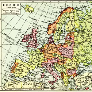
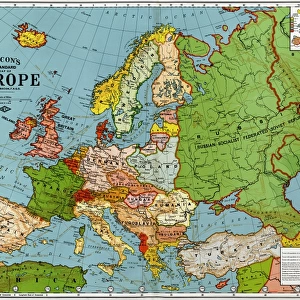
Tote Bag : Central Europe Antique Victorian Engraved Colored Map, 1899


![]()
Home Decor from Fine Art Storehouse
Central Europe Antique Victorian Engraved Colored Map, 1899
Very Rare, Beautifully Illustrated Antique Victorian Engraved Colored Map of Central Europe Antique Victorian Engraved Colored Map, 1899. Source: Original edition from my own archives. Copyright has expired on this artwork. Digitally restored
Unleash your creativity and transform your space into a visual masterpiece!
bauhaus1000
Media ID 19834463
Canvas Tote Bag
Our tote bags are made from soft, durable, poly-poplin fabric and include a one inch (2.5cm) black strap for easy carrying on your shoulder. All seams are double-stitched for added durability. Each tote bag is machine-washable in cold water and is printed on both sides using the same image. Approximate size of bag is 50x33cm (20"x13")
Our tote bags are made from soft durable fabric and include a strap for easy carrying
Estimated Product Size is 50cm x 32.7cm (19.7" x 12.9")
These are individually made so all sizes are approximate
FEATURES IN THESE COLLECTIONS
> Fine Art Storehouse
> Map
> Historical Maps
> Arts
> Street art graffiti
> Digital art
> Digital paintings
> Europe
> Related Images
> Maps and Charts
> Related Images
EDITORS COMMENTS
This stunning print showcases a Central Europe Antique Victorian Engraved Colored Map from 1899, making it an incredibly rare and beautifully illustrated piece of art. Sourced directly from the original edition in the archives of the photographer, this map holds historical significance and has been digitally restored to its former glory. The intricate details and vibrant colors on this map transport us back to a bygone era, where cartography was both an art form and a scientific endeavor. Every inch of this antique masterpiece is adorned with meticulous engravings that depict the countries, cities, rivers, and mountains of Central Europe during the Victorian era. As we gaze upon this artwork, our imagination takes flight as we envision explorers using maps like these to navigate uncharted territories or historians studying past civilizations. The faded edges and delicate lines tell stories of countless adventures undertaken by those who sought knowledge or simply marveled at the world's wonders. With copyright long expired on this remarkable piece, it now serves as a window into history for all to appreciate. Whether displayed in a study room or adorning the walls of a living space, this print invites us to delve into Central Europe's rich heritage while adding an air of elegance and sophistication to any setting. Capture your own slice of history with this extraordinary Central Europe Antique Victorian Engraved Colored Map print from Fine Art Storehouse – an exquisite homage to both artistry and exploration.
MADE IN THE UK
Safe Shipping with 30 Day Money Back Guarantee
FREE PERSONALISATION*
We are proud to offer a range of customisation features including Personalised Captions, Color Filters and Picture Zoom Tools
SECURE PAYMENTS
We happily accept a wide range of payment options so you can pay for the things you need in the way that is most convenient for you
* Options may vary by product and licensing agreement. Zoomed Pictures can be adjusted in the Basket.