Tote Bag > Europe > Netherlands > Maps
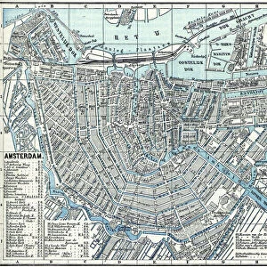
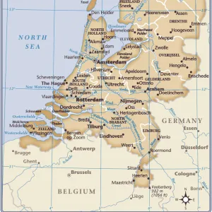
Tote Bag : Amsterdam city map 1895


![]()
Home Decor from Fine Art Storehouse
Amsterdam city map 1895
Meyers Konversations-Lexikon. Ein Nachschlagewerk des allgemeinen Wissens, 5th edition 17 volumes Bibliographisches Institut - Leipzig 1895-1897
Unleash your creativity and transform your space into a visual masterpiece!
THEPALMER
Media ID 13611791
© This content is subject to copyright
Amsterdam Atlas Mythological Figure Dutch Culture Netherlands Paper World Map
Canvas Tote Bag
Our tote bags are made from soft, durable, poly-poplin fabric and include a one inch (2.5cm) black strap for easy carrying on your shoulder. All seams are double-stitched for added durability. Each tote bag is machine-washable in cold water and is printed on both sides using the same image. Approximate size of bag is 50x33cm (20"x13")
Our tote bags are made from soft durable fabric and include a strap for easy carrying
Estimated Product Size is 50cm x 32.7cm (19.7" x 12.9")
These are individually made so all sizes are approximate
FEATURES IN THESE COLLECTIONS
> Fine Art Storehouse
> The Magical World of Illustration
> Palmer Illustrated Collection
> Fine Art Storehouse
> Map
> Historical Maps
> Fine Art Storehouse
> Map
> USA Maps
> Europe
> Netherlands
> Amsterdam
> Europe
> Netherlands
> Maps
> Europe
> Netherlands
> Posters
> Europe
> Netherlands
> Related Images
> Europe
> Related Images
> Maps and Charts
> Netherlands
> Maps and Charts
> Related Images
> Maps and Charts
> World
> North America
> United States of America
> Maps
EDITORS COMMENTS
This print showcases an exquisite piece of history, the "Amsterdam city map 1895" from Meyers Konversations-Lexikon. This renowned atlas, a treasure trove of knowledge in its time, was published by Bibliographisches Institut in Leipzig between 1895 and 1897. The map itself is a mesmerizing blend of artistry and cartography, meticulously engraved to depict the Dutch capital's physical geography. With its horizontal orientation, this antique illustration transports us back to the Amsterdam of yesteryears. Every intricate detail on this paper relic tells a story about the city's rich cultural heritage and significance as one of Europe's most prominent capitals. As we delve into this historical gem, we are reminded that maps like these were once invaluable tools for navigation and exploration. They served as windows into different worlds, guiding adventurers through uncharted territories with their carefully plotted routes. The inclusion of mythological figures adds an enchanting touch to this already captivating composition. It serves as a reminder that even in the realm of cartography, imagination played an essential role in capturing people's fascination with distant lands. "The Amsterdam city map 1895" by THEPALMER is not just a mere photograph; it is a portal to another era—a testament to human curiosity and our eternal quest for knowledge. Whether you're an avid collector or simply captivated by history, this remarkable artwork will transport you back in time while celebrating the enduring beauty of Dutch culture.
MADE IN THE UK
Safe Shipping with 30 Day Money Back Guarantee
FREE PERSONALISATION*
We are proud to offer a range of customisation features including Personalised Captions, Color Filters and Picture Zoom Tools
SECURE PAYMENTS
We happily accept a wide range of payment options so you can pay for the things you need in the way that is most convenient for you
* Options may vary by product and licensing agreement. Zoomed Pictures can be adjusted in the Basket.