Tote Bag > Europe > France > Paris > Maps
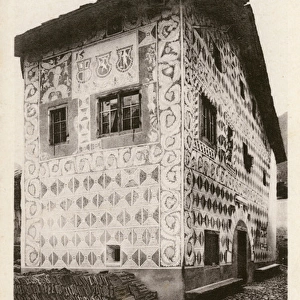
Tote Bag : Map of the regions and districts of France, known as the Carte de Necker


![]()
Home Decor from Fine Art Finder
Map of the regions and districts of France, known as the Carte de Necker
ARH213911 Map of the regions and districts of France, known as the Carte de Necker, 1789 (coloured engraving) by French School, (18th century); Centre Historique des Archives Nationales, Paris, France; (add.info.: carte des generalites et baillages de la France; finance minister under Louis XVI; ); eCentre Historique des Archives Nationales; eArchives Charmet; French, out of copyright
Media ID 23359106
© Centre Historique des Archives Nationales Archives Charmet / Bridgeman Images
Canvas Tote Bag
Our tote bags are made from soft, durable, poly-poplin fabric and include a one inch (2.5cm) black strap for easy carrying on your shoulder. All seams are double-stitched for added durability. Each tote bag is machine-washable in cold water and is printed on both sides using the same image. Approximate size of bag is 50x33cm (20"x13")
Our tote bags are made from soft durable fabric and include a strap for easy carrying
Estimated Product Size is 50cm x 32.7cm (19.7" x 12.9")
These are individually made so all sizes are approximate
FEATURES IN THESE COLLECTIONS
> Fine Art Finder
> Artists
> French School
> Fine Art Finder
> Artists
> Joseph Noel Paton
> Fine Art Finder
> Maps (celestial & Terrestrial)
> Europe
> France
> Paris
> Maps
> Europe
> France
> Paris
> Politics
> Europe
> France
> Paris
> Related Images
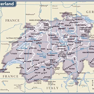
> Europe
> Switzerland
> Maps
> Europe
> Switzerland
> Posters
> Europe
> Switzerland
> Related Images
> Maps and Charts
> Related Images
> Maps and Charts
> Switzerland
EDITORS COMMENTS
This print showcases the historic "Map of the regions and districts of France, known as the Carte de Necker". Created in 1789 by an anonymous French School artist, this coloured engraving offers a fascinating glimpse into the political landscape of 18th century France. The map is housed at the Centre Historique des Archives Nationales in Paris, France. The Carte de Necker was named after Jacques Necker, a prominent Swiss-born politician who served as finance minister under Louis XVI. This intricate map depicts the generalities and bailiwicks of France during that time period. With its detailed illustrations and precise cartographic representation, it provides valuable insights into how administrative divisions were organized within the country. Neatly engraved lines demarcate provinces while vibrant colors bring life to each region. As viewers explore this piece, they are transported back to an era when maps were not only functional tools but also works of art. Bridgeman Images has skillfully captured this historical gem from their archives for all to appreciate. It serves as a reminder of both Jacques Necker's influence on French politics and his lasting legacy as a financier and statesman. Displayed here with pride, this print invites us to delve deeper into history and marvel at the craftsmanship that went into creating such an important document from centuries past.
MADE IN THE UK
Safe Shipping with 30 Day Money Back Guarantee
FREE PERSONALISATION*
We are proud to offer a range of customisation features including Personalised Captions, Color Filters and Picture Zoom Tools
SECURE PAYMENTS
We happily accept a wide range of payment options so you can pay for the things you need in the way that is most convenient for you
* Options may vary by product and licensing agreement. Zoomed Pictures can be adjusted in the Basket.