Tote Bag > Fine Art Finder > Maps (celestial & Terrestrial)
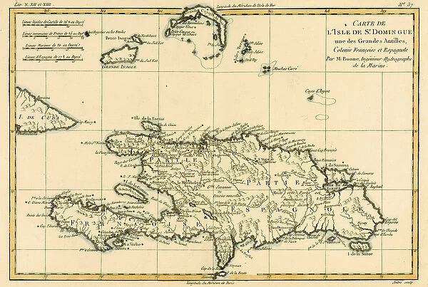
Tote Bag : The French and Spanish Colony of the Island of St Dominic of the Greater Antilles
![]()

Home Decor from Fine Art Finder
The French and Spanish Colony of the Island of St Dominic of the Greater Antilles
KW205897 The French and Spanish Colony of the Island of St Dominic of the Greater Antilles, from Atlas de Toutes les Parties Connues du Globe Terrestre by Guillaume Raynal (1713-96), published J L Pellet, Geneva, 1780 (coloured engraving) by Bonne, Charles Marie Rigobert (1727-95); Private Collection; Ken Welsh; French, out of copyright
Media ID 12755491
© www.bridgemanimages.com
Caribbean Dominican Republic Haiti West Indies
Canvas Tote Bag
Our tote bags are made from soft, durable, poly-poplin fabric and include a one inch (2.5cm) black strap for easy carrying on your shoulder. All seams are double-stitched for added durability. Each tote bag is machine-washable in cold water and is printed on both sides using the same image. Approximate size of bag is 50x33cm (20"x13")
Our tote bags are made from soft durable fabric and include a strap for easy carrying
Estimated Product Size is 50cm x 32.7cm (19.7" x 12.9")
These are individually made so all sizes are approximate
FEATURES IN THESE COLLECTIONS
> Fine Art Finder
> Artists
> Charles Marie Rigobert Bonne
> Fine Art Finder
> Maps (celestial & Terrestrial)
EDITORS COMMENTS
This print titled "The French and Spanish Colony of the Island of St Dominic of the Greater Antilles" takes us back in time to the 18th century Caribbean. The image, a coloured engraving from Atlas de Toutes les Parties Connues du Globe Terrestre by Guillaume Raynal, showcases the stunning beauty and rich history of this region. As we gaze upon this map-like artwork, we are transported to an era when St Dominic (now known as Hispaniola) was divided between two colonial powers - France and Spain. The intricate details on the print highlight various settlements, rivers, mountains, and coastlines that shaped life on this island during that period. The vibrant colors used in this engraving bring to life the lush landscapes and turquoise waters surrounding St Dominic. It is a visual feast for anyone fascinated by cartography or interested in exploring historical geography. This print serves as a window into an important chapter in Caribbean history. It reminds us of how European colonization profoundly impacted these lands while also showcasing their natural splendor. Whether you have ties to St Dominic or simply appreciate art that tells stories from our past, this piece is sure to captivate your imagination and transport you to another time.
MADE IN THE UK
Safe Shipping with 30 Day Money Back Guarantee
FREE PERSONALISATION*
We are proud to offer a range of customisation features including Personalised Captions, Color Filters and Picture Zoom Tools
SECURE PAYMENTS
We happily accept a wide range of payment options so you can pay for the things you need in the way that is most convenient for you
* Options may vary by product and licensing agreement. Zoomed Pictures can be adjusted in the Basket.


