
Maps Collection
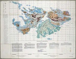
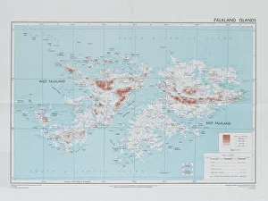
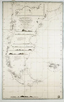
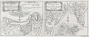
The Falkland Islands are an archipelago located in the South Atlantic Ocean off the coast of Argentina and Chile
Choose a picture from our Maps Collection for your Wall Art and Photo Gifts
20 items


All Professionally Made to Order for Quick Shipping
-
Maps Collection
The Falkland Islands are an archipelago located in the South Atlantic Ocean off the coast of Argentina and Chile. The islands have a total land area of 4,700 square miles and are home to over 3,000 people. The islands have a rich history, with archaeological evidence indicating human habitation dating back to the Paleolithic era. Maps of Falkland Islands South America provide an invaluable resource for understanding the geography of this remote region. They show the location of major settlements, roads, rivers and other features such as mountains and glaciers. In addition to providing detailed information about physical features on land, it also depict important marine features such as shipping lanes and fishing grounds and can essential for anyone wishing to explore or learn more about this fascinating part of South America.
+
Our beautiful pictures are available as Framed Prints, Photos, Wall Art and Photo Gifts
The Maps of Falkland Islands South America collection from Media Storehouse is a stunning array of wall art and framed prints that showcase the beauty and history of this remote region. Our collection features a range of vintage maps, charts, and illustrations that offer a unique glimpse into the geography, topography, and political boundaries of the Falkland Islands. These prints are perfect for anyone interested in exploring the rich cultural heritage and natural wonders of this fascinating part of South America. Whether you're an avid collector or simply looking to add some visual interest to your home or office decor, these maps are sure to impress. With their high-quality printing techniques and attention to detail, Media Storehouse has created a truly exceptional collection that captures the essence of this remarkable region. So why not take a closer look at these beautiful prints today? You won't be disappointed.
+
What are Maps of Falkland Islands South America art prints?
Maps of Falkland Islands South America art prints are high-quality reproductions of vintage and contemporary maps depicting the geography, topography, and landmarks of the Falkland Islands. These prints showcase the intricate details and accuracy of cartographic art, making them an ideal choice for collectors, historians, geographers or anyone interested in exploring this beautiful region. These maps come in a variety of styles including antique parchment paper prints, modern canvas wall art or framed posters that can be displayed on any wall. We offer a unique insight into the history and culture of the Falkland Islands as well as their strategic importance to South America. Whether you're looking to decorate your home or office with stunning artwork or searching for a thoughtful gift for someone special who loves travel and exploration, Maps of Falkland Islands South America art prints are an excellent choice. With their timeless appeal and exceptional quality, they will bring joy to anyone who appreciates fine artistry.
+
What Maps of Falkland Islands South America art prints can I buy from Media Storehouse?
We offer a wide range of art prints featuring maps of the Falkland Islands in South America. These maps showcase the geography, topography, and landmarks of the islands in intricate detail. You can choose from vintage-style maps that capture the history and heritage of the region or modern-day satellite images that provide an accurate representation of its current landscape. The collection includes various sizes and formats to suit your preferences, including framed or unframed prints, canvas prints, and posters. Whether you are looking for a unique piece to decorate your home or office space or searching for a thoughtful gift for someone who loves geography or travel, we have something to offer. These art prints are made using high-quality materials that ensure durability and longevity. They are perfect for adding character to any room while also serving as educational tools for those interested in learning more about this fascinating part of South America.
+
How do I buy Maps of Falkland Islands South America art prints?
To purchase Maps of Falkland Islands South America art prints from Media Storehouse, you can browse our extensive collection online. Simply search for the specific map or artwork that you are interested in and add it to your cart. You will then be prompted to enter your shipping and payment information before completing the transaction. We offer a wide range of printing options including canvas, framed prints, and posters. They use high-quality materials to ensure that each print is vibrant and long-lasting. In addition to Maps of Falkland Islands South America, Media Storehouse also has a vast selection of other maps and artwork from around the world. Whether you're looking for vintage maps or contemporary designs, they have something for everyone. Purchasing art prints from Media Storehouse is a simple process that allows you to bring beautiful pieces into your home or office with ease.
+
How much do Maps of Falkland Islands South America art prints cost?
We offer a wide range of art prints featuring maps of Falkland Islands South America. The cost of these prints varies depending on the size and type of print you choose. We have a variety of options available, including framed or unframed prints, canvas prints, and poster prints. Our prices are competitive and reflect the quality of our products. We take pride in offering high-quality art prints that are both affordable and visually stunning. Whether you're looking for a small print to hang in your home or office or a larger piece to make a statement in your living space, we have something for everyone. We believe that everyone should have access to beautiful artwork at an affordable price. That's why we work hard to keep our prices low while maintaining the highest standards of quality. So if you're looking for maps of Falkland Islands South America art prints, look no further than Media Storehouse.
+
How will my Maps of Falkland Islands South America art prints be delivered to me?
We take great care in ensuring that your Maps of Falkland Islands South America art prints are delivered to you in the best possible condition. We use high-quality packaging materials to protect your print during transit and ensure it arrives at your doorstep without any damage. Your print will be carefully rolled and placed inside a sturdy cardboard tube for safe transportation. It will then be shipped via our trusted delivery partners who will handle it with utmost care until it reaches you. We offer worldwide shipping options so no matter where you are located, you can enjoy our beautiful collection of Maps of Falkland Islands South America art prints from the comfort of your own home. Once your order has been dispatched, we will send you an email notification with tracking information so that you can keep track of its progress and estimated delivery date.