Home > Arts > Artists > S > John Speed
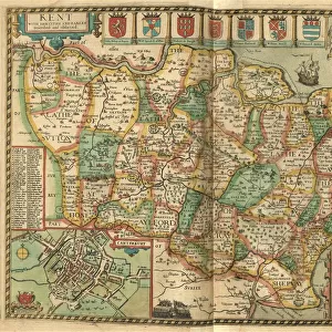
John Speeds map of Surrey, 1611

![]()
Wall Art and Photo Gifts from Sheffield City Archives
John Speeds map of Surrey, 1611
Image from Theatre of the Empire of Great Britaine presenting an exact geography of the Kingdomes of Ireland, Scotland, Ireland, and the Iles adioyning with The Shires, Hundreds, Cities and Shire Towns, within ye Kingdome of England, divided and described by John Speed (original at Sheffield Libraries: 914.2 SQ).
Note these images are from 400-year-old maps from a tightly bound volume. They show some wear and tear as well as the binding in the middle of the image
Sheffield City Archives and Local Studies Library has an unrivalled collection of images of Sheffield, England
Media ID 26400166
© Sheffield City Council - All Rights Reserved
FEATURES IN THESE COLLECTIONS
> Arts
> Artists
> S
> John Speed
> Europe
> Republic of Ireland
> Maps
> Europe
> United Kingdom
> England
> Maps
> Europe
> United Kingdom
> England
> Sheffield
> Europe
> United Kingdom
> England
> Surrey
> Related Images
> Europe
> United Kingdom
> England
> Wells
> Europe
> United Kingdom
> Scotland
> Maps
> Sheffield City Archives
> Maps and Plans
> John Speed's County Maps, 1611
EDITORS COMMENTS
This print showcases John Speed's map of Surrey, dating back to 1611. Extracted from the renowned "Theatre of the Empire of Great Britaine" this image offers a glimpse into the exact geography of England during that era. Preserved within Sheffield Libraries, it is an invaluable piece of history. Despite its age, this 400-year-old map exhibits remarkable detail and precision. It presents a comprehensive overview of Surrey's shires, hundreds, cities, and shire towns within the Kingdom of England. The intricate cartography skillfully illustrates the region's topography and landmarks as envisioned by John Speed himself. However, time has left its mark on these ancient maps. As evident in this photo print, wear and tear are visible due to their age and extensive use over centuries. Additionally, one can observe the binding in the middle of the image—a reminder that these maps were once part of a tightly bound volume. These images serve as a testament to Sheffield City Archives' commitment to preserving historical artifacts for future generations to appreciate. They offer us an opportunity to delve into our past and explore how our landscapes have evolved throughout centuries
MADE IN THE UK
Safe Shipping with 30 Day Money Back Guarantee
FREE PERSONALISATION*
We are proud to offer a range of customisation features including Personalised Captions, Color Filters and Picture Zoom Tools
SECURE PAYMENTS
We happily accept a wide range of payment options so you can pay for the things you need in the way that is most convenient for you
* Options may vary by product and licensing agreement. Zoomed Pictures can be adjusted in the Basket.