Premium Framed Print > Arts > Artists > T > Tasman
Premium Framed Print : Maps / New Zealand


![]()
Framed Photos from Mary Evans Picture Library
Maps / New Zealand
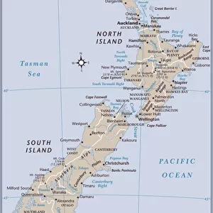
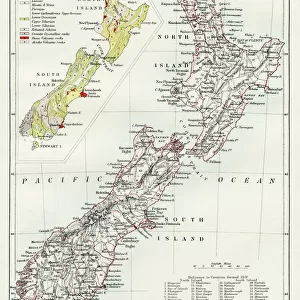
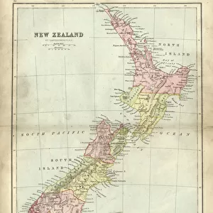
A map of New Zealand Date: 1908
Mary Evans Picture Library makes available wonderful images created for people to enjoy over the centuries
Media ID 7148349
© Mary Evans Picture Library 2015 - https://copyrighthub.org/s0/hub1/creation/maryevans/MaryEvansPictureID/10149914
17"x15" (43x38cm) Premium Frame
FSC real wood frame with double mounted 10x8 print. Double mounted with white conservation mountboard. Frame moulding comprises stained composite natural wood veneers (Finger Jointed Pine) 39mm wide by 21mm thick. Archival quality Fujifilm CA photo paper mounted onto 1mm card. Overall outside dimensions are 17x15 inches (431x381mm). Rear features Framing tape to cover staples, 50mm Hanger plate, cork bumpers. Glazed with durable thick 2mm Acrylic to provide a virtually unbreakable glass-like finish. Acrylic Glass is far safer, more flexible and much lighter than typical mineral glass. Moreover, its higher translucency makes it a perfect carrier for photo prints. Acrylic allows a little more light to penetrate the surface than conventional glass and absorbs UV rays so that the image and the picture quality doesn't suffer under direct sunlight even after many years. Easily cleaned with a damp cloth. Please note that, to prevent the paper falling through the mount window and to prevent cropping of the original artwork, the visible print may be slightly smaller to allow the paper to be securely attached to the mount without any white edging showing and to match the aspect ratio of the original artwork.
FSC Real Wood Frame and Double Mounted with White Conservation Mountboard - Professionally Made and Ready to Hang
Estimated Image Size (if not cropped) is 17.3cm x 24.4cm (6.8" x 9.6")
Estimated Product Size is 38.1cm x 43.1cm (15" x 17")
These are individually made so all sizes are approximate
Artwork printed orientated as per the preview above, with portrait (vertical) orientation to match the source image.
FEATURES IN THESE COLLECTIONS
> Maps and Charts
> Related Images
> Oceania
> New Zealand
> Maps
> Oceania
> New Zealand
> Related Images
> Popular Themes
> North Island
EDITORS COMMENTS
1. Title: "Vintage Map of New Zealand from 1908: A Journey Through Time to the Pacific Island Nation's Early Cartographic History" This vintage map print, dated 1908, showcases the intricate detail and historical significance of New Zealand's cartographic evolution. The map, which depicts the islands of New Zealand and its surrounding waters, is a testament to the rich maritime history of this Pacific nation. New Zealand, an archipelago of more than 700 islands, is located in the southwestern Pacific Ocean. The map, published in 1908, illustrates the islands' geographical features with remarkable accuracy for the time. The North and South Islands, the two largest islands, are clearly marked, along with numerous smaller islands scattered throughout the waters. The map also highlights the Tasman Sea, which separates New Zealand from Australia to the west, and the Pacific Ocean to the east. The Cook Strait, the narrow body of water that separates the North and South Islands, is also clearly marked. The map's title, "New Zealand and its Islands," is positioned at the top, while the scale of the map and the cartographer's name, "J.H. Colquhoun," are located at the bottom. This map, produced over a century ago, offers a fascinating glimpse into the cartographic history of New Zealand. It reflects the advancements in mapping technology and the growing European interest in exploring the Pacific region during the late 19th and early 20th centuries. The map's intricate detail and historical significance make it an essential addition to any collection focusing on New Zealand, Pacific Island history, or cartography. In conclusion, this vintage map print of New Zealand from 1908 is a captivating piece of cartographic history that offers a unique perspective on the geography and maritime exploration of this fascinating Pacific nation.
MADE IN THE UK
Safe Shipping with 30 Day Money Back Guarantee
FREE PERSONALISATION*
We are proud to offer a range of customisation features including Personalised Captions, Color Filters and Picture Zoom Tools
SECURE PAYMENTS
We happily accept a wide range of payment options so you can pay for the things you need in the way that is most convenient for you
* Options may vary by product and licensing agreement. Zoomed Pictures can be adjusted in the Basket.