Premium Framed Print > Historic > Ancient civilizations > Roman Empire > Roman art
Premium Framed Print : Map of The Byzantine Empire


![]()
Framed Photos from Mary Evans Picture Library
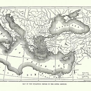
Map of The Byzantine Empire
A map showing the extent of the Byzantine Empire - the predominantly Greek-speaking continuation of the Roman Empire during Late Antiquity and the Middle Ages. Date: 1800
Mary Evans Picture Library makes available wonderful images created for people to enjoy over the centuries
Media ID 11575341
© Mary Evans / Grenville Collins Postcard Collection
1800 Anatolia Assyria Byzantine Byzantium Continuation Crete Cyprus Mediterranean Minor
17"x15" (43x38cm) Premium Frame
FSC real wood frame with double mounted 10x8 print. Double mounted with white conservation mountboard. Frame moulding comprises stained composite natural wood veneers (Finger Jointed Pine) 39mm wide by 21mm thick. Archival quality Fujifilm CA photo paper mounted onto 1mm card. Overall outside dimensions are 17x15 inches (431x381mm). Rear features Framing tape to cover staples, 50mm Hanger plate, cork bumpers. Glazed with durable thick 2mm Acrylic to provide a virtually unbreakable glass-like finish. Acrylic Glass is far safer, more flexible and much lighter than typical mineral glass. Moreover, its higher translucency makes it a perfect carrier for photo prints. Acrylic allows a little more light to penetrate the surface than conventional glass and absorbs UV rays so that the image and the picture quality doesn't suffer under direct sunlight even after many years. Easily cleaned with a damp cloth. Please note that, to prevent the paper falling through the mount window and to prevent cropping of the original artwork, the visible print may be slightly smaller to allow the paper to be securely attached to the mount without any white edging showing and to match the aspect ratio of the original artwork.
FSC Real Wood Frame and Double Mounted with White Conservation Mountboard - Professionally Made and Ready to Hang
Estimated Image Size (if not cropped) is 24.4cm x 19cm (9.6" x 7.5")
Estimated Product Size is 43.1cm x 38.1cm (17" x 15")
These are individually made so all sizes are approximate
Artwork printed orientated as per the preview above, with landscape (horizontal) orientation to match the source image.
FEATURES IN THESE COLLECTIONS
> Arts
> Artists
> R
> Roman Roman
> Asia
> Cyprus
> Related Images
> Asia
> Related Images
> Asia
> Turkey
> Related Images
> Europe
> Greece
> Related Images
> Historic
> Ancient civilizations
> Ancient Greece
> Greek history
> Historic
> Ancient civilizations
> Roman Empire
> Roman art
> Popular Themes
> Maps and Charts
EDITORS COMMENTS
This stunning antique map print depicts the Byzantine Empire in the year 1800, providing a captivating glimpse into the historical extent of this predominantly Greek-speaking continuation of the Roman Empire during Late Antiquity and the Middle Ages. The Byzantine Empire, also known as the Eastern Roman Empire, is shown here in all its grandeur, stretching from the Adriatic and Ionian seas in the west to the Black Sea and the Caucasus Mountains in the east, and from Anatolia in Asia Minor to the Balkans and Italy in Europe. The Mediterranean Sea dominates the map, with the Byzantine territories surrounding it, including the islands of Cyprus and Crete. Anatolia, a significant region in Asia Minor, is also clearly marked, as well as the Asian territories of Assyria and Thracia. The empire's eastern borders extend into modern-day Turkey, with Constantinople, the imperial capital, situated at the center of the map. The Byzantine Empire's rich history is evident in this map, which showcases the empire's significant cultural and political influence during Late Antiquity and the Middle Ages. The empire's legacy can still be seen today in the Greek and Turkish cultures, as well as in the many historical sites and landmarks that bear witness to its enduring impact. This map print is an essential addition to any history or geography collection, offering a unique perspective on the historical development of Europe, Asia, and the Mediterranean world. Its intricate details and accurate depiction of the Byzantine Empire's territories make it a fascinating and educational piece, transporting us back in time to an era of great historical significance.
MADE IN THE UK
Safe Shipping with 30 Day Money Back Guarantee
FREE PERSONALISATION*
We are proud to offer a range of customisation features including Personalised Captions, Color Filters and Picture Zoom Tools
SECURE PAYMENTS
We happily accept a wide range of payment options so you can pay for the things you need in the way that is most convenient for you
* Options may vary by product and licensing agreement. Zoomed Pictures can be adjusted in the Basket.