Premium Framed Print > Arts > Photorealistic artworks > Meticulous attention to detail > Detailed artwork
Premium Framed Print : George Bradshaws Plan of Rome, Italy 1896


![]()
Framed Photos from MapSeeker
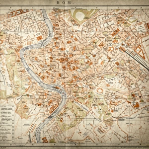
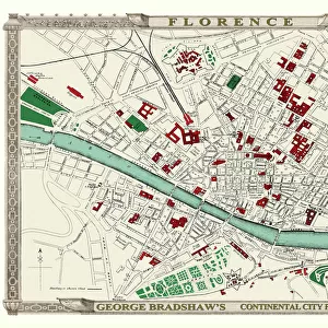
George Bradshaws Plan of Rome, Italy 1896
This is a very detailed Plan of Rome showing the streets, canals, principal buildings, railways and railway stations, as well as the many ancient Roman sites. A comprehensive list of 69 sites of interest are numbered and referenced to the plan, that include the Pantheon, Circus Maximus, Colossium and the Vatican. The plan has been meticulously recreated in colour and republished without and fold creases by Mapseeker, from a rare antique original black and white fold up tourist city map. The 29 that were originally published as fold up maps featuring the principal cities of Europe are now rare, yet popular at their time among those who could then explore Europe by railway for the first time
Welcome to the Mapseeker Image library and enter an historic gateway to one of the largest on-line collections of Historic Maps, Nostalgic Views, Vista's and Panorama's from a World gone by.
Media ID 20347981
© Mapseeker Publishing Ltd
Bradshaw City Map Bradshaw City Plan Bradshaw Map Europe City Europe City Plan European City Map European City Plan Historic Map Old Town Plan Italian City
23"x19" (58x48cm) Premium Frame
FSC real wood frame with double mounted 16x12 print. Double mounted with white conservation mountboard. Frame moulding comprises stained composite natural wood veneers (Finger Jointed Pine) 39mm wide by 21mm thick. Archival quality Fujifilm CA photo paper mounted onto 1mm card. Overall outside dimensions are 23x19 inches (584x482mm). Rear features Framing tape to cover staples, 50mm Hanger plate, cork bumpers. Glazed with durable thick 2mm Acrylic to provide a virtually unbreakable glass-like finish. Acrylic Glass is far safer, more flexible and much lighter than typical mineral glass. Moreover, its higher translucency makes it a perfect carrier for photo prints. Acrylic allows a little more light to penetrate the surface than conventional glass and absorbs UV rays so that the image and the picture quality doesn't suffer under direct sunlight even after many years. Easily cleaned with a damp cloth. Please note that, to prevent the paper falling through the mount window and to prevent cropping of the original artwork, the visible print may be slightly smaller to allow the paper to be securely attached to the mount without any white edging showing and to match the aspect ratio of the original artwork.
FSC Real Wood Frame and Double Mounted with White Conservation Mountboard - Professionally Made and Ready to Hang
Estimated Image Size (if not cropped) is 39.6cm x 26.4cm (15.6" x 10.4")
Estimated Product Size is 58.4cm x 48.2cm (23" x 19")
These are individually made so all sizes are approximate
Artwork printed orientated as per the preview above, with landscape (horizontal) orientation to match the source image.
FEATURES IN THESE COLLECTIONS
> MapSeeker
> Maps of Europe
> Maps of Italy PORTFOLIO
> Animals
> Mammals
> Muridae
> Maximus
> Arts
> Artists
> W
> George White
> Arts
> Modern art pieces
> Pop art
> Street art
> Arts
> Photorealistic artworks
> Detailed art pieces
> Masterful detailing in art
> Arts
> Photorealistic artworks
> Meticulous attention to detail
> Detailed artwork
> Arts
> Photorealistic artworks
> Meticulous attention to detail
> Fine art
> Europe
> Italy
> Lazio
> Rome
EDITORS COMMENTS
This stunning print showcases George Bradshaw's meticulously detailed Plan of Rome from 1896. The map provides a comprehensive view of the city, highlighting its intricate network of streets, canals, principal buildings, railways, and railway stations. What sets this plan apart is its inclusion of numerous ancient Roman sites that have shaped the city's rich history. The vibrant colors used in this reproduction bring new life to an original black and white fold-up tourist map. MapSeeker Publishing Ltd has taken great care to ensure that there are no fold creases on this republished version. This particular edition is part of a rare collection that originally featured 29 fold-up maps showcasing Europe's principal cities during a time when railway travel was revolutionizing exploration. The Plan of Rome serves as an invaluable resource for those interested in delving into the wonders of this iconic city. With 69 numbered sites of interest referenced directly on the plan, visitors can easily locate renowned landmarks such as the Pantheon, Circus Maximus, Colosseum, and even Vatican City. Whether you're a history enthusiast or simply fascinated by cartography, this old town plan offers a captivating glimpse into Rome's past. It not only captures the essence of one European city but also represents an era when rail travel opened up new possibilities for adventure across the continent.
MADE IN THE UK
Safe Shipping with 30 Day Money Back Guarantee
FREE PERSONALISATION*
We are proud to offer a range of customisation features including Personalised Captions, Color Filters and Picture Zoom Tools
SECURE PAYMENTS
We happily accept a wide range of payment options so you can pay for the things you need in the way that is most convenient for you
* Options may vary by product and licensing agreement. Zoomed Pictures can be adjusted in the Basket.