Premium Framed Print > Arts > Artists > T > John Tallis
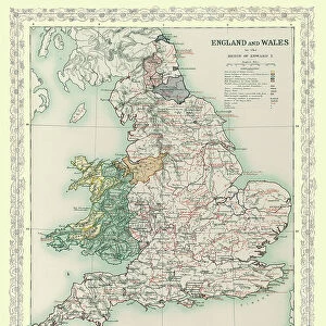
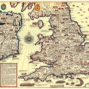
Premium Framed Print : England & Wales 1851


![]()
Framed Photos from MapSeeker
England & Wales 1851
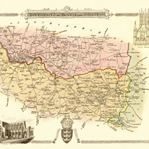
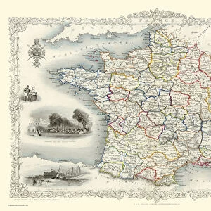
A fine facimile artworked from an antique original map of England and Wales, issued as part of the 1851 edition of John Tallis and Companys " The Illustrated Atlas and Modern History of the World"
Welcome to the Mapseeker Image library and enter an historic gateway to one of the largest on-line collections of Historic Maps, Nostalgic Views, Vista's and Panorama's from a World gone by.
Media ID 20347485
© Mapseeker Publishing Ltd
John Tallis John Tallis Map Tallis Map
23"x19" (58x48cm) Premium Frame
FSC real wood frame with double mounted 16x12 print. Double mounted with white conservation mountboard. Frame moulding comprises stained composite natural wood veneers (Finger Jointed Pine) 39mm wide by 21mm thick. Archival quality Fujifilm CA photo paper mounted onto 1mm card. Overall outside dimensions are 23x19 inches (584x482mm). Rear features Framing tape to cover staples, 50mm Hanger plate, cork bumpers. Glazed with durable thick 2mm Acrylic to provide a virtually unbreakable glass-like finish. Acrylic Glass is far safer, more flexible and much lighter than typical mineral glass. Moreover, its higher translucency makes it a perfect carrier for photo prints. Acrylic allows a little more light to penetrate the surface than conventional glass and absorbs UV rays so that the image and the picture quality doesn't suffer under direct sunlight even after many years. Easily cleaned with a damp cloth. Please note that, to prevent the paper falling through the mount window and to prevent cropping of the original artwork, the visible print may be slightly smaller to allow the paper to be securely attached to the mount without any white edging showing and to match the aspect ratio of the original artwork.
FSC Real Wood Frame and Double Mounted with White Conservation Mountboard - Professionally Made and Ready to Hang
Estimated Image Size (if not cropped) is 26.4cm x 39.6cm (10.4" x 15.6")
Estimated Product Size is 48.2cm x 58.4cm (19" x 23")
These are individually made so all sizes are approximate
Artwork printed orientated as per the preview above, with portrait (vertical) orientation to match the source image.
FEATURES IN THESE COLLECTIONS
> MapSeeker
> Maps from the British Isles
> England with Wales PORTFOLIO
> Arts
> Artists
> T
> John Tallis
> Europe
> United Kingdom
> England
> Maps
> Europe
> United Kingdom
> Wales
> Maps
> Europe
> United Kingdom
> Wales
> Posters
> Europe
> United Kingdom
> Wales
> Related Images
> Maps and Charts
> Related Images
> Maps and Charts
> Wales
> Maps and Charts
> World
EDITORS COMMENTS
This exquisite print showcases a remarkable piece of history - the England & Wales map from 1851. Painstakingly reproduced from an antique original, this fine facsimile artwork is a testament to the craftsmanship and attention to detail that went into creating maps during that era. Part of John Tallis and Company's renowned "The Illustrated Atlas and Modern History of the World" this map offers a fascinating glimpse into England and Wales as they were over 150 years ago. Every inch of the land is meticulously depicted, capturing not only geographical features but also important cities, towns, rivers, and roads. As you gaze upon this old map of England and Wales, you can't help but be transported back in time. The intricate illustrations evoke a sense of nostalgia for an era long gone - when horse-drawn carriages traversed winding country lanes, bustling marketplaces buzzed with activity, and grand castles stood proudly amidst picturesque landscapes. John Tallis was known for his exceptional cartographic skills, which are evident in every stroke on this English map. His collaboration with talented engraver John Rapkin resulted in masterpieces like these that continue to captivate us today. Whether you're an avid historian or simply appreciate beautiful works of art, this print will undoubtedly become a cherished addition to your collection. It serves as both a window into our past and a reminder of the enduring beauty found within vintage maps like these.
MADE IN THE UK
Safe Shipping with 30 Day Money Back Guarantee
FREE PERSONALISATION*
We are proud to offer a range of customisation features including Personalised Captions, Color Filters and Picture Zoom Tools
SECURE PAYMENTS
We happily accept a wide range of payment options so you can pay for the things you need in the way that is most convenient for you
* Options may vary by product and licensing agreement. Zoomed Pictures can be adjusted in the Basket.