Premium Framed Print > Europe > United Kingdom > England > West Yorkshire > Halifax
Premium Framed Print : Old Map of Bradford 1851 by John Tallis


![]()
Framed Photos from MapSeeker
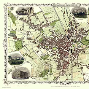
Old Map of Bradford 1851 by John Tallis
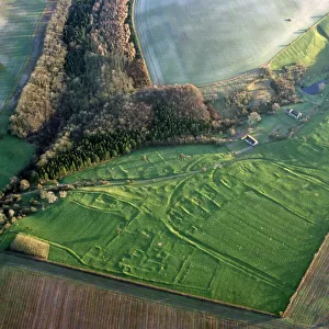
In this John Tallis 1851 map of Bradford in west Yorkshire the railways are now well established, buildings now stretch out from the centre of Bradford along the main artery roads. There are no fewer than seven illustrations on the plan of Bradford, Yorkshire. These illustrations are of the Terminus of the Bradford and Halifax Railway, Infirmary Cemetery, St Peters Church, Roman Catholic Church, Airdale College and St Georges Hall
Welcome to the Mapseeker Image library and enter an historic gateway to one of the largest on-line collections of Historic Maps, Nostalgic Views, Vista's and Panorama's from a World gone by.
Media ID 20347638
Historic Map John Tallis John Tallis Map Old Town Plan Tallis Map Bradford Bradford City
23"x19" (58x48cm) Premium Frame
FSC real wood frame with double mounted 16x12 print. Double mounted with white conservation mountboard. Frame moulding comprises stained composite natural wood veneers (Finger Jointed Pine) 39mm wide by 21mm thick. Archival quality Fujifilm CA photo paper mounted onto 1mm card. Overall outside dimensions are 23x19 inches (584x482mm). Rear features Framing tape to cover staples, 50mm Hanger plate, cork bumpers. Glazed with durable thick 2mm Acrylic to provide a virtually unbreakable glass-like finish. Acrylic Glass is far safer, more flexible and much lighter than typical mineral glass. Moreover, its higher translucency makes it a perfect carrier for photo prints. Acrylic allows a little more light to penetrate the surface than conventional glass and absorbs UV rays so that the image and the picture quality doesn't suffer under direct sunlight even after many years. Easily cleaned with a damp cloth. Please note that, to prevent the paper falling through the mount window and to prevent cropping of the original artwork, the visible print may be slightly smaller to allow the paper to be securely attached to the mount without any white edging showing and to match the aspect ratio of the original artwork.
FSC Real Wood Frame and Double Mounted with White Conservation Mountboard - Professionally Made and Ready to Hang
Estimated Image Size (if not cropped) is 39.6cm x 26.4cm (15.6" x 10.4")
Estimated Product Size is 58.4cm x 48.2cm (23" x 19")
These are individually made so all sizes are approximate
Artwork printed orientated as per the preview above, with landscape (horizontal) orientation to match the source image.
FEATURES IN THESE COLLECTIONS
> MapSeeker
> British Town And City Plans
> English & Welsh PORTFOLIO
> Animals
> Mammals
> Muridae
> Peters Mouse
> Arts
> Artists
> T
> John Tallis
> Europe
> United Kingdom
> England
> West Yorkshire
> Bradford
> Europe
> United Kingdom
> England
> West Yorkshire
> Halifax
> Europe
> United Kingdom
> England
> West Yorkshire
> Related Images
> Europe
> United Kingdom
> England
> Yorkshire
> Bradford
> Europe
> United Kingdom
> England
> Yorkshire
> Halifax
> Europe
> United Kingdom
> England
> Yorkshire
> Old Town
> Europe
> United Kingdom
> England
> Yorkshire
> Related Images
> Europe
> United Kingdom
> England
> Yorkshire
> Well
EDITORS COMMENTS
This print showcases an exquisite piece of history - the Old Map of Bradford from 1851, meticulously crafted by John Tallis. Transporting us back in time, this map reveals a bustling town with well-established railways and buildings extending along the main roads. The attention to detail is truly remarkable. What makes this map even more fascinating are the seven illustrations adorning its surface. Each illustration offers a glimpse into different aspects of life in Bradford during that era. From the impressive Terminus of the Bradford and Halifax Railway to the serene Infirmary Cemetery, these images bring forth a sense of nostalgia and curiosity about what once was. The religious landmarks featured on this map also hold significance within the community. St Peters Church stands tall as a symbol of faith, while the Roman Catholic Church represents diversity and inclusivity. Airdale College serves as a testament to education's importance, while St Georges Hall exudes grandeur and elegance. As we explore this old town plan, it becomes evident how much has changed over time while appreciating how certain elements have stood steadfast throughout history. This historic map not only provides valuable insights into Bradford's past but also sparks our imagination about its evolution into the vibrant city it is today.
MADE IN THE UK
Safe Shipping with 30 Day Money Back Guarantee
FREE PERSONALISATION*
We are proud to offer a range of customisation features including Personalised Captions, Color Filters and Picture Zoom Tools
SECURE PAYMENTS
We happily accept a wide range of payment options so you can pay for the things you need in the way that is most convenient for you
* Options may vary by product and licensing agreement. Zoomed Pictures can be adjusted in the Basket.