Premium Framed Print > Arts > Artists > C > William Caxton
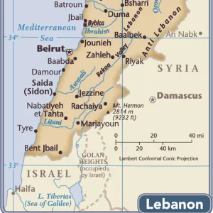
Premium Framed Print : Map To Illustrate The Campaign in Palestine, 1919. Creator: London Geographical Institute


![]()
Framed Photos from Heritage Images
Map To Illustrate The Campaign in Palestine, 1919. Creator: London Geographical Institute
Map To Illustrate The Campaign in Palestine, 1919. Map of the Eastern Mediterrean and the Middle East, showing Cyprus, Port Said in Egypt, parts of Turkey and what are now Syria, the Lebanon, Israel and the Occupied Territories including Gaza. From " The History of the Great European War: its causes and effects", Vol. IX, by W. Stanley Macbean Knight. [Caxton Pulishing Company, Limited, London, 1919]
Heritage Images features heritage image collections
Media ID 19047561
© The Print Collector/Heritage Images
Beirut Bur Said Campaign Caxton Publishing Company Caxton Pulishing Company Caxton Pulishing Company Lim Caxton Pulishing Company Limited Caxton Pulishing Company Ltd Cyprus Israel Knight Lebanon Limited London Geographical Institute Mediterranean Palestine Port Said Stanley Macbean Stanley Macbean Knight Syria Turkey W Stanley Macbean W Stanley Macbean Knight William Stanley Macbean William Stanley Macbean Knight Gaza
23"x19" (58x48cm) Premium Frame
FSC real wood frame with double mounted 16x12 print. Double mounted with white conservation mountboard. Frame moulding comprises stained composite natural wood veneers (Finger Jointed Pine) 39mm wide by 21mm thick. Archival quality Fujifilm CA photo paper mounted onto 1mm card. Overall outside dimensions are 23x19 inches (584x482mm). Rear features Framing tape to cover staples, 50mm Hanger plate, cork bumpers. Glazed with durable thick 2mm Acrylic to provide a virtually unbreakable glass-like finish. Acrylic Glass is far safer, more flexible and much lighter than typical mineral glass. Moreover, its higher translucency makes it a perfect carrier for photo prints. Acrylic allows a little more light to penetrate the surface than conventional glass and absorbs UV rays so that the image and the picture quality doesn't suffer under direct sunlight even after many years. Easily cleaned with a damp cloth. Please note that, to prevent the paper falling through the mount window and to prevent cropping of the original artwork, the visible print may be slightly smaller to allow the paper to be securely attached to the mount without any white edging showing and to match the aspect ratio of the original artwork.
FSC Real Wood Frame and Double Mounted with White Conservation Mountboard - Professionally Made and Ready to Hang
Estimated Image Size (if not cropped) is 26.3cm x 39.6cm (10.4" x 15.6")
Estimated Product Size is 48.2cm x 58.4cm (19" x 23")
These are individually made so all sizes are approximate
Artwork printed orientated as per the preview above, with portrait (vertical) orientation to match the source image.
FEATURES IN THESE COLLECTIONS
> Africa
> Egypt
> Related Images
> Arts
> Artists
> C
> William Caxton
> Arts
> Artists
> S
> Syrian Syrian
> Asia
> Cyprus
> Related Images
> Asia
> Israel
> Related Images
EDITORS COMMENTS
This print showcases a historic map titled "Map To Illustrate The Campaign in Palestine, 1919". Created by the esteemed London Geographical Institute, this detailed map takes us back to the early 20th century during World War I. It depicts the Eastern Mediterranean and Middle East regions, featuring significant locations such as Cyprus, Port Said in Egypt, parts of Turkey, Syria, Lebanon, Israel, and the Occupied Territories including Gaza. Originally published in "The History of the Great European War: its causes and effects". Volume IX by W. Stanley Macbean Knight in 1919 under Caxton Publishing Company Limited in London. This remarkable piece offers valuable insights into the geographical features and strategic importance of these areas during that time. With vibrant colors highlighting coastlines and urban centers like Beirut in Lebanon and Bur Said in Egypt along with sea routes connecting various territories across the Mediterranean Sea, this map serves as a visual representation of an era marked by conflict and transformation. As we delve into this historical artifact captured by The Print Collector from Heritage Images collection, we are transported to a pivotal moment where world powers were vying for control over these lands amidst the chaos of war. It stands as a testament to human endeavors to understand our surroundings while shedding light on how past events have shaped our present reality.
MADE IN THE UK
Safe Shipping with 30 Day Money Back Guarantee
FREE PERSONALISATION*
We are proud to offer a range of customisation features including Personalised Captions, Color Filters and Picture Zoom Tools
SECURE PAYMENTS
We happily accept a wide range of payment options so you can pay for the things you need in the way that is most convenient for you
* Options may vary by product and licensing agreement. Zoomed Pictures can be adjusted in the Basket.