Premium Framed Print > Historic > Ancient civilizations > Ancient Greece > Greek history
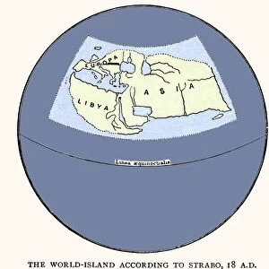
Premium Framed Print : STRABO WORLD MAP, c20 A. D. According to the writings of the Greek geographer Strabo


![]()
Framed Photos from Granger
STRABO WORLD MAP, c20 A. D. According to the writings of the Greek geographer Strabo
STRABO WORLD MAP, c20 A.D. According to the writings of the Greek geographer Strabo: a 19th century reconstruction
Granger holds millions of images spanning more than 25,000 years of world history, from before the Stone Age to the dawn of the Space Age
Media ID 6617437
1st Century Geographer Hellenic Republic World Strabo
23"x19" (58x48cm) Premium Frame
FSC real wood frame with double mounted 16x12 print. Double mounted with white conservation mountboard. Frame moulding comprises stained composite natural wood veneers (Finger Jointed Pine) 39mm wide by 21mm thick. Archival quality Fujifilm CA photo paper mounted onto 1mm card. Overall outside dimensions are 23x19 inches (584x482mm). Rear features Framing tape to cover staples, 50mm Hanger plate, cork bumpers. Glazed with durable thick 2mm Acrylic to provide a virtually unbreakable glass-like finish. Acrylic Glass is far safer, more flexible and much lighter than typical mineral glass. Moreover, its higher translucency makes it a perfect carrier for photo prints. Acrylic allows a little more light to penetrate the surface than conventional glass and absorbs UV rays so that the image and the picture quality doesn't suffer under direct sunlight even after many years. Easily cleaned with a damp cloth. Please note that, to prevent the paper falling through the mount window and to prevent cropping of the original artwork, the visible print may be slightly smaller to allow the paper to be securely attached to the mount without any white edging showing and to match the aspect ratio of the original artwork.
FSC Real Wood Frame and Double Mounted with White Conservation Mountboard - Professionally Made and Ready to Hang
Estimated Image Size (if not cropped) is 39.6cm x 23.2cm (15.6" x 9.1")
Estimated Product Size is 58.4cm x 48.2cm (23" x 19")
These are individually made so all sizes are approximate
Artwork printed orientated as per the preview above, with landscape (horizontal) orientation to match the source image.
FEATURES IN THESE COLLECTIONS
> Granger Art on Demand
> Maps
> Arts
> Landscape paintings
> Waterfall and river artworks
> River artworks
> Europe
> Greece
> Related Images
> Historic
> Ancient civilizations
> Ancient Greece
> Greek history
> Maps and Charts
> Early Maps
> Maps and Charts
> Popular Maps
> Maps and Charts
> Related Images
> Maps and Charts
> World
EDITORS COMMENTS
The Strabo World Map, dating back to the 1st century and reconstructed in the 19th century, is a fascinating piece of ancient cartography. Based on the writings of Greek geographer Strabo, this map offers us a glimpse into how people perceived the world over two thousand years ago. This intricate print showcases an array of geographical features that were known at the time. From vast rivers snaking through continents to mountain ranges dividing lands, it captures the essence of ancient exploration and discovery. The attention to detail is remarkable, with each region carefully labeled in Greek script. As we study this map, we are transported back in time to an era when knowledge about distant lands was limited but eagerly sought after. It serves as a testament to human curiosity and our innate desire to understand our surroundings. The Strabo World Map also reminds us of Greece's rich intellectual heritage. Strabo's writings have been invaluable in reconstructing this map and provide valuable insights into ancient geography. This print pays homage not only to his work but also highlights Greece's contribution to global knowledge throughout history. Displayed proudly by Granger Art on Demand, this image invites viewers on a journey through time and space. Whether you're an avid historian or simply appreciate beautiful artwork, this print will undoubtedly spark your imagination and ignite your sense of wonder about our ever-evolving world.
MADE IN THE UK
Safe Shipping with 30 Day Money Back Guarantee
FREE PERSONALISATION*
We are proud to offer a range of customisation features including Personalised Captions, Color Filters and Picture Zoom Tools
SECURE PAYMENTS
We happily accept a wide range of payment options so you can pay for the things you need in the way that is most convenient for you
* Options may vary by product and licensing agreement. Zoomed Pictures can be adjusted in the Basket.